The severe weather threat diminished significantly Thursday morning around Charlotte, with just a few isolated downpours before 6 a.m.
(Click PLAY to watch Christine Rapp's explain why it's so windy out Thursday)
Most of the activity cleared out of Charlotte for the morning commute. Skies will clear Thursday but conditions will be quite windy and much cooler, with wind gusts near 30 mph and highs only in the low-to-mid 60s.
Temps will get even colder Friday as we fall into the upper 30s overnight. Highs on Friday will barely reach 60 degrees, and near-freezing temps arrive by Saturday morning.
(Click PLAY to watch Channel 9's Instagram weather story)
Tornadoes and apparent twisters, rain, hail across Southeast
Severe storms raking the Southeast unleashed one large tornado and more than a half-dozen apparent twisters Wednesday, toppling trees, roughing up South Carolina's "peach capital" and raining out golfers warming up for the Masters.
A powerful tornado toppled trees and downed power lines in rural Georgia and similar scenes played out in spots around Alabama and South Carolina amid drenching rain, high winds and scattered hail - some as big as baseballs.
The severe weather outbreak was the second to hit the South in less than a week, but no deaths or significant injuries were reported by Wednesday evening. Storms on Sunday and Monday killed five people, including a Mississippi woman who desperately called 911 from a car that plunged into a rain-swollen creek.
Portions of Kentucky and Georgia were still under threat of tornadoes late Wednesday, and flash flooding was possible in the Atlanta area, according to the National Weather Service.
Authorities in Johnston, South Carolina, a town of 2,300 that calls itself The Peach Capital of The World, reported a possible tornado there damaged about a dozen buildings. Crews couldn't immediately check nearby peach orchards but authorities said those were already severely damaged by a late March hard freeze.
Johnston Mayor Terrence Cullbreath said he opened a local armory as a shelter and that lights were out and many streets were blocked by fallen trees. Thousands had lost power across the three states Wednesday, with utilities struggling to keep up.
"We need power back," Cullbreath said by phone. "But there likely are more storms coming and they can't get the power back in bad weather."
In southwest Georgia, a powerful tornado that touched down at midday traveled some distance on the ground in rural Stewart County, National Weather Service Meteorologist Keith Stellman said. It left downed power lines and trees on roads, said Sandra James, a sheriff's office dispatcher.
Elsewhere, a suspected tornado touched down in southeastern Alabama, before crossing into Georgia, forecasters said. All told at least nine possible tornados had been reported across Alabama, Georgia and South Carolina as the day wore on with more reports likely as the storms continued into the evening.
In Alabama, the storm hit an area dotted with vacation and full-time homes around Lake Eufaula, damaging some homes and knocking down power lines and trees, said official John Taylor, with the Henry County Emergency Management Agency. He also reported no deaths or injuries there.
Tornadoes weren't the only threat Wednesday. The nation's Storm Prediction Center said winds were blowing at near 70 mph in some areas, downing trees in several states.
Alabama Gov. Robert Bentley declared a state of emergency and deployed 50 National Guard soldiers. There also were multiple school closings in Alabama and many early dismissals in South Carolina.
The Federal Aviation Administration temporarily halted flights to Atlanta's airport but those later resumed with arrival and departure delays.
As storms bore down on Augusta National, the venerable east Georgia club shut down for the second time this week as golfers tried to get in some practice before the start of the Masters tournament later this week. Officials cut short the final afternoon practice and ordered rain-bedraggled fans to leave the course. Augusta National also closed Monday because of heavy rains.
In the east Alabama city of Oxford, convenience store manager Don Copeland was working up courage to go outside and look at his truck after a storm dumped so much grape-sized hail the ground turned white.
"It's a 2015. I just made a $550 payment this morning," Copeland said.
The weather service said it had gotten reports of baseball-sized hail in the west Alabama town of Camden, but only small ice pellets fell at the McGraw-Webb Chevrolet Inc.
"Thank goodness we did not get that. We just had pea-sized hail, and two or three cars were damaged," said Evan Bohannon, who handles online sales for the dealership.
In central Kentucky, Mike Callahan of the National Weather Service in Louisville said some areas received large amounts of hail Wednesday evening - some of it several inches deep. The hydrologist also reported winds up to 72 mph in places.
Kentucky State Police Trooper Joshua Lawson also said in an email that a mobile home in Kentucky's Henry County overturned with a family inside, but no one was injured amid the high winds.
Below are updates as severe weather moved through the Carolinas:
4:30 a.m.
Tree limbs fell on power lines overnight on Ilford Street, just off The Plaza, knocking out power to about 60 customers in the area. Crews hope to have the power back on by 7 a.m.
Another tree took down lines on Atherton Street, near Dilworth, knocking out power to about 50 customers.
___
4 a.m.
The Severe Thunderstorm Watch has been canceled for all counties except Lancaster County. It will expire at 7 a.m.
___
3:30 a.m.
A tree that fell on Ferguson Road near Crowders Creek Road in Gaston County caused three cars to crash into it in separate crashes overnight. No injuries were reported and the tree was moved out of the roadway by 3 a.m.
Highway Patrol says 3 cars crashed into this tree after the storm knocked it onto Ferguson Ridge Road in Gaston County. #WakeUpWith9 @wsoctv pic.twitter.com/R1QNyBXgvY
— Mark Barber (@_MarkBarber_) April 6, 2017
___
2 a.m.
The storms are falling apart as they continue to move east, bringing mainly rain and gusty winds for now.
___
1:15 a.m.
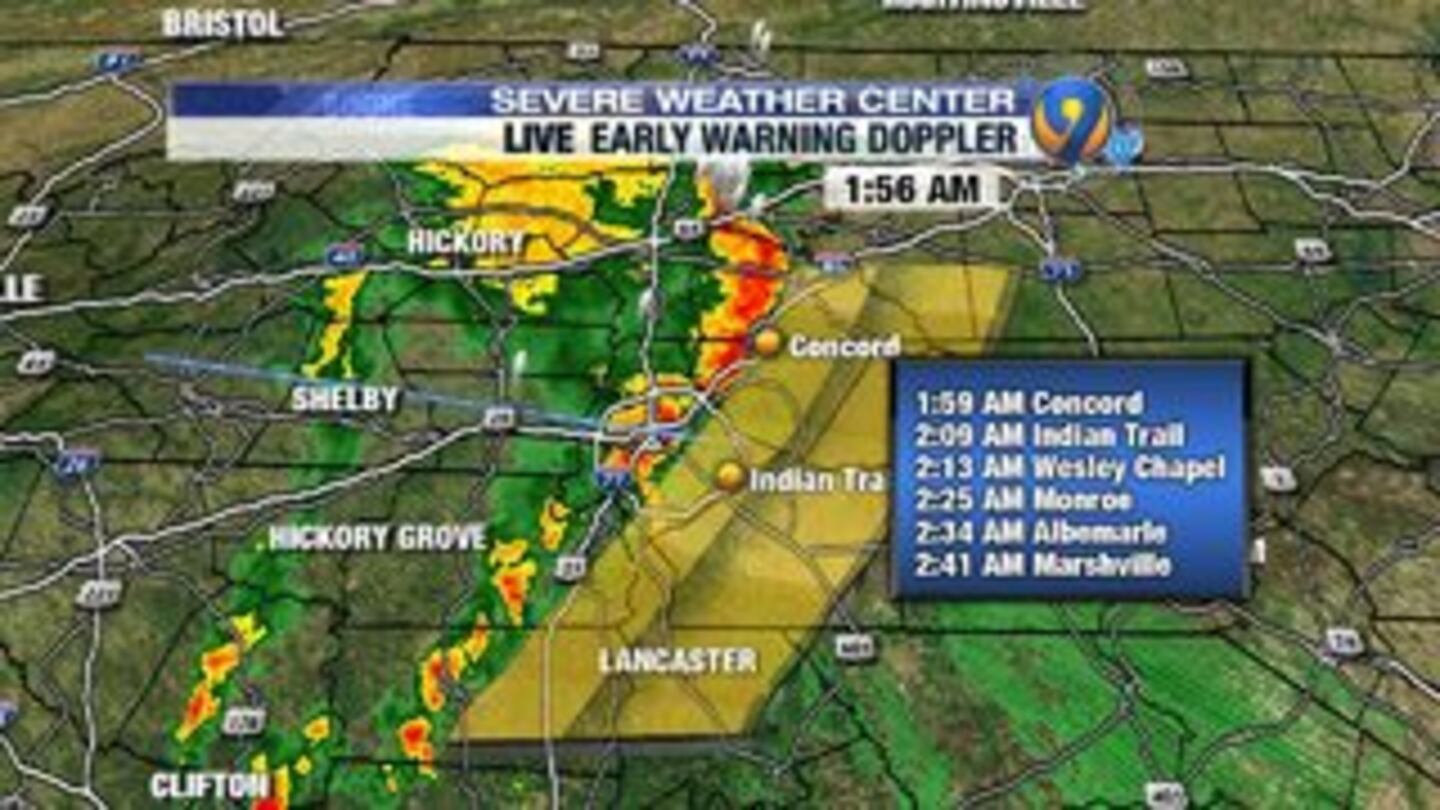
The line of storms is moving east quickly and should arrive in Charlotte at about 2 a.m.
RADAR UPDATE: Line of storms is moving east very quickly. Should be near Charlotte around 2am. @wsoctv pic.twitter.com/g23je88v55
— Vicki Graf (@VickiGrafWX) April 6, 2017
___
1:10 a.m.
Dime-sized hail has been reported in Cleveland County.
___
1 a.m.
Severe thunderstorm warning issued for Chester and York counties until 1:45 a.m
Severe t-storm warning along/west of Hwy 321 in York/Chester counties. Storms heading NE at 60+ mph #scwx pic.twitter.com/nMKQWYjMBP
— Steve Udelson (@SUdelsonWSOC9) April 6, 2017
___
12:54 a.m.
Severe thunderstorm warning issued for Alexander, Catawba, Iredell and Lincoln counties until 1:30 a.m.
___
12:35 a.m.
A severe thunderstorm warning has been issued for Caldwell, Cleveland, Burke, Catawba and Lincoln counties until 1:15 a.m. The top threats are damaging wind and hail.
SEVERE THUNDERSTORM WARNING for Caldwell, Cleveland, Burke, Catawba, Lincoln Counties until 1:15am. Top threats: damaging wind/hail pic.twitter.com/LaojmVeHFL
— Vicki Graf (@VickiGrafWX) April 6, 2017
___
11:55 p.m.
A severe thunderstorm watch has been issued for Mecklenburg and area counties. Main threats are heavy rain, hail and damaging wind.
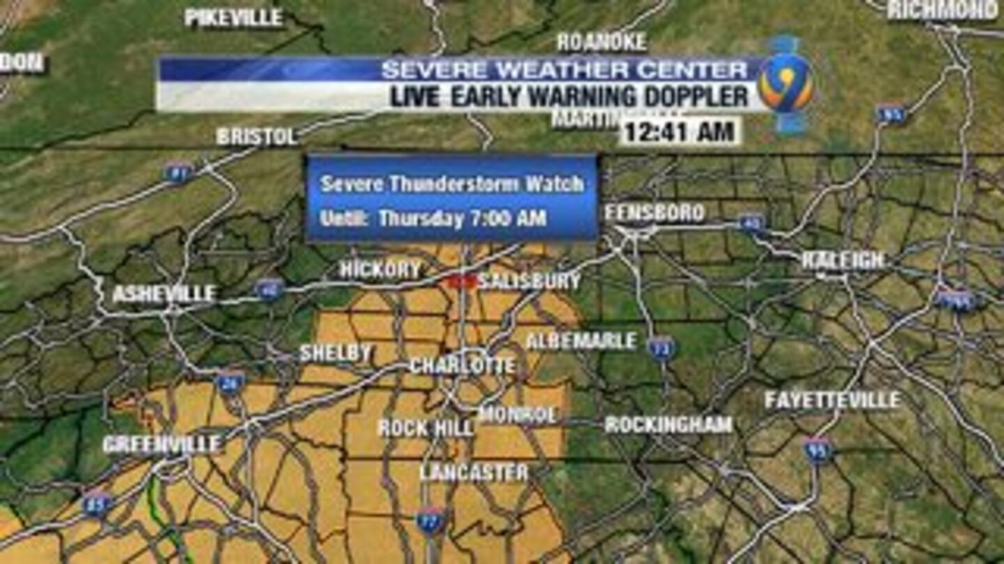
The watch is until 7 a.m.
The main threats are heavy rain, lightning, hail and damaging wind. The chance for a tornado is low.
This is one of our Futurecast models to show you the timeline of when storms will arrive in your neighborhood. @wsoctv @WSOCWeather pic.twitter.com/jilw7JSCJW
— Vicki Graf (@VickiGrafWX) April 6, 2017
___
11 p.m.
The system is pushing into the mountains bringing heavy rain. Any one of these storms moving east to Charlotte could have damaging winds. The storms are expected to arrive in Charlotte at about 3-4 a.m.
___
10 p.m.
The severity of the storms does not look as serious as it did earlier, according to information our meteorologists are gathering. The chance of a major outbreak that is widespread is less likely, but don’t let your guard down.
The leading edge of the system is 100 miles west of Boone.
Storms are expected to arrive at midnight in the mountains and about 3 a.m. for the Charlotte area.
___
9 p.m.
Click to watch Steve Udelson's latest weather update.
8:30 p.m.
Conditions continue to stay quiet this evening as a cold front travels through central Tennessee. This line of storms will move into the Carolinas after midnight, bringing the risk of strong wind and heavy rain.
Leading edge of the developing squall line over TN is still over 200 miles west of #CLT #ncwx #scwx pic.twitter.com/XBr2S5Ub2e
— WSOCWeather (@WSOCWeather) April 5, 2017
Storms still look to clear out by the morning drive on Thursday.
___
5:45 p.m.
Showers will dry out for the early evening hours as temperatures stay in the 60s. Conditions will change as a cold front moves through closer to midnight, bringing a risk for strong to severe thunderstorms.
The risks include strong, damaging wind; heavy rain and an isolated tornado. The storms look to pass through quickly, clearing by the Thursday morning commute.
___
4:30 p.m.
Steady showers will continue through the evening drive with strong winds and frequent lightning. We will see a break in the rain Wednesday evening with another line of rain possible with the cold front around midnight.
Watch Eyewitness News at 5 p.m. for the latest from Steve Udelson on the forecast. If you can't get to a TV, watch our livestream here.
___
3 p.m.
The Charlotte area has seen a moderate to heavy batch of rain Wednesday afternoon with few claps of thunder, but nothing severe. Rain rates are over an inch per hour.
The strongest storms are along and south of I-20 in the Columbia, S.C. area and into the midlands.
There will be an extended break in the storms after the initial batch moves through. More scattered showers and storms are possible Wednesday evening that could bring heavy rain, damaging winds and the slight chance of a tornado.
___
2:30 p.m.
Meteorologist Christine Rapp has an update on the storm's latest track as it moves toward the Carolinas.
___
12:50 p.m.
Nearly all of North and South Carolina are in an enhanced risk for severe weather.
Nearly all of NC/SC now in at least an Enhanced Risk for severe weather (numerous severe storms.) Moderate (widespread storms) south of CLT! pic.twitter.com/3Umjs97sOY
— WSOCWeather (@WSOCWeather) April 5, 2017
___
12:05 p.m.
The FAA has issued a ground stop at Charlotte Douglas International Airport due to weather moving in. No flights arriving in Charlotte until 2 p.m.
___
11:25 a.m.
A cluster of downpours is bringing intense lightning over Chester. It stays south of Charlotte, but will impact Lancaster and Monroe.
#Lightning picking up near #RockHill / #Chester SC #CLTstorm pic.twitter.com/bIS1dZqeWB
— John Ahrens (@JohnAhrensWSOC9) April 5, 2017
11:15 a.m.
Charlotte Douglas Airport officials reporting 30-45 minute departure delays due tot he weather.
___
10:30 a.m.
Chester County schools dismissing early due to weather. All students will be dismissed by 12:30 p.m.
Channel 9 radar starting to look serious. Storms moving into York and Chester counties. pic.twitter.com/nyOmOJxLsQ
— Greg Suskin (@GSuskinWSOC9) April 5, 2017
___
10:15 a.m.
Heavy rain from the Atlanta area will make its way into Charlotte around noon.
New watch may be issued just to our south shortly, could include our far southern counties. https://t.co/wXqyeRUZgB
— Keith Monday (@kmondayWSOC9) April 5, 2017
___
WEDNESDAY OUTLOOK: We'll be watching for the development of two rounds of storms Wednesday in the Charlotte area, one late in the afternoon and the other overnight.
Here's the latest timeline for storms coming in this PM and again late tonight. Both could bring severe weather, but higher risk late. pic.twitter.com/0E61i17flY
— WSOCWeather (@WSOCWeather) April 5, 2017
The afternoon storms could be severe, with damaging winds and heavy rains the main threat. The tornado risk associated with these storms is low though.
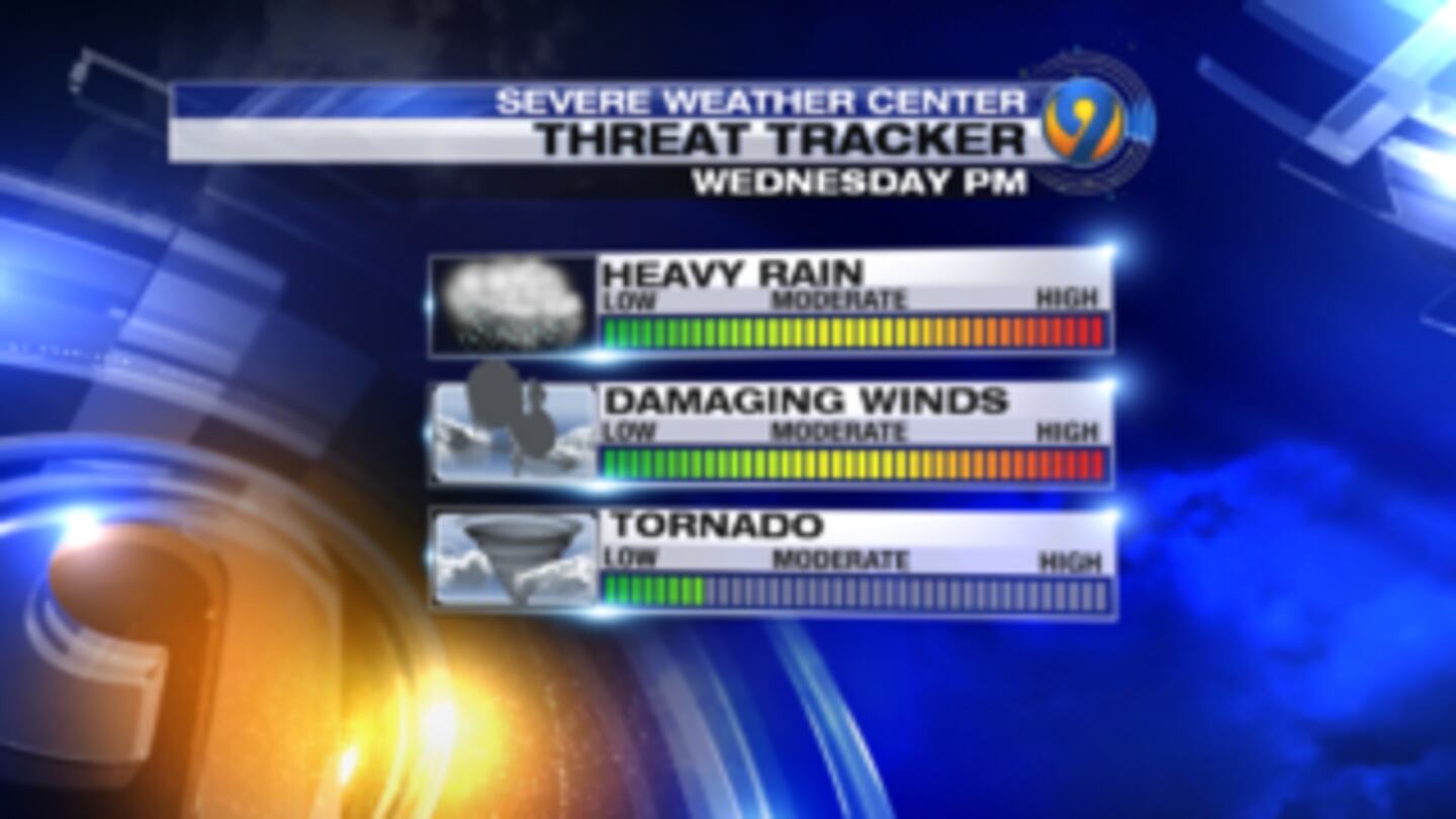
A second line of storms later Wednesday night could also bring severe weather, with more widespread damaging wind the main threat. A lot still needs to play out well to the west and south of Charlotte before we know exactly what is coming our way.
[DOWNLOAD: Free WSOC-TV weather app with severe weather alerts]
Stronger storms to our south Wednesday afternoon may limit the severity of the afternoon cells in the Carolinas. Also, the storm line overnight could break up as it arrives after midnight.
(Click PLAY to watch Keith Monday's severe weather outlook)
Severe weather threat leads to early school dismissals
The threat of severe weather in the Carolinas has led local school officials to announce early dismissals.
The National Weather Service is calling for thunderstorms, high winds, hail and possible tornadoes on Wednesday.
All school districts in the Columbia area are dismissing middle and high school students early, some as early as 11 a.m. Elementary school classes will be dismissed at 11 a.m. Wednesday, and after-school activities are canceled.
Some schools in the Upstate are also dismissing early Wednesday due to weather concerns. The National Weather Service has confirmed four tornadoes touched down in the state's northwestern area during severe weather earlier this week.
The National Weather Service is predicting widespread thunderstorms across much of Alabama and Georgia and into the Florida Panhandle and southwestern South Carolina.
THURSDAY: The storms will clear out of the area early Thursday, before the morning rush hour. Conditions will be very windy on Thursday though, and cooler, with temperatures in the mid-60s.
WEEKEND PREVIEW: The sunshine and quiet weather will return by the end of the work week. Highs on Friday will be cooler than average, topping off in the low 60s. We'll gradually warm into the low 70s by Sunday under plenty of sun.
Weather Resources:
Cox Media Group
/cloudfront-us-east-1.images.arcpublishing.com/cmg/LH3JSJEF3VBLRJLJQESEAG34AM.png)