Heavy downpours overnight caused flooding issues early Monday morning. Charlotte recorded nearly 1.2 inches of rain since midnight.
There is a threat for windy conditions later in the evening with gusts in Charlotte that could reach 20 mph.
[DOWNLOAD THE WSOC-TV WEATHER APP]
A huge tree came down around 2 a.m. Monday in south Charlotte, blocking lanes on Providence Road near Sharon Amity Road, and there were several roads closed because of high water.
#Breaking: Huge tree down on Providence Rd near Sharon Amity. Blocking lanes. Team Coverage on @wsoctv at 4:30a #WakeUpWith9 pic.twitter.com/lTFP0hAnLp
— WSOCTV (@wsoctv) January 23, 2017
[CLICK here for creek webcams]
Roads closed due to high water or trees down:
- Addison Drive (McMullen Creek flooding)
- West Arrowood Road at Whitehall Park Drive near I-485
- 800 block of Westinghouse Boulevard
- 2800 block of Providence Road (tree down)
- Elm Lane ant Endhaven Lane
- Marvin Road at Ardrey Kell Road, near the Union County line
Those strong winds also caused some power outages across the area. At 4:30 a.m., York County had the most outages, with about 900 customers in the dark, while Lincoln County had nearly 400.
[Tornado safety: The difference between watch, warning]
No severe weather is expected Monday, but steady rain and strong wind can be expected. Wind gusts could get up to 30-40 mph across the Carolinas.
Sunshine will finally return to the Carolinas by Tuesday, with temperatures staying well above average in the mid-60s. Mostly sunny conditions will continue Wednesday, with highs near 70 degrees.
LATER IN THE WEEK: The warm temperatures won't hang around for long, as a front moving through on Thursday will bring rain and cooler weather. Highs Thursday and Friday will stay in the 40-50s with sunshine returning by Friday afternoon.
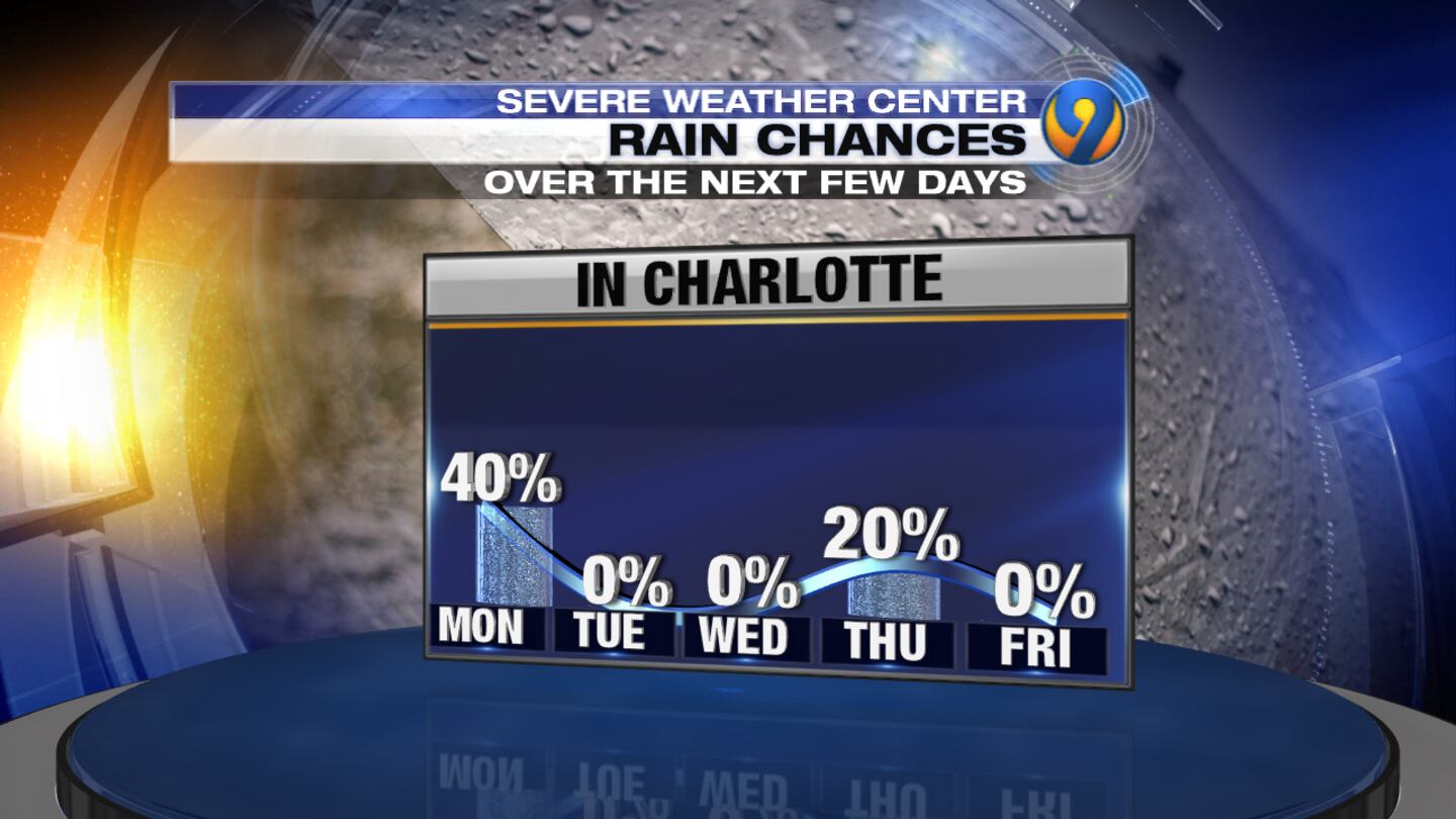
WEEKEND PREVIEW: Expect a mix of sun and clouds with temperatures staying at/slightly below average.
Weather Resources:
Cox Media Group
/cloudfront-us-east-1.images.arcpublishing.com/cmg/LH3JSJEF3VBLRJLJQESEAG34AM.png)


