CHARLOTTE, N.C — The 2017 severe weather season has started out with a fury and there is no sign of it slowing down.
This week marks Severe Weather Preparedness Week for both North and South Carolina. Although severe weather can happen during any season, spring is typically the prime time for severe weather to occur in the Carolinas.

Quiet weather days are the best opportunity to make sure you and your family know what to do during a severe weather situation, whether it is a tornado, hurricane, flooding or even a wildfire.
DID YOU KNOW: #NC and #SC rank 17th, 19th for highest average annual tornadoes across the country. #SevereWeatherPreparedness @wsoctv pic.twitter.com/tNqpU2kBhF
— Christine Rapp (@christinerappwx) March 6, 2017
Preparation is key to staying safe and minimizing impacts. Some simple safety precautions include:
- Downloading the WSOC-TV Weather App and sign up for the weather notifications
- Purchase a battery-powered NOAA Weather Radio
- Practice your severe weather plan with your family
- Know where to go in your home in the case of a tornado
- Have an emergency bag ready with important documents in a waterproof bag in the case of an evacuation due to a hurricane, flooding or wildfire
- Keep trees and branches trimmed near your home
- Secure loose objects before severe weather moves in
Knowing the difference between a watch and warning is one of the most important details in severe weather planning. A Severe Thunderstorm or Tornado Watch is issued by the National Weather Service when conditions are favorable for strong wind, large hail or tornadoes. Watches are typically issued hours before severe weather develops in the area, giving you and your family time to prepare for what may form later in the day.
[KEEPING YOU SAFE: Knowing the difference between a watch and a warning]
A Severe Thunderstorm or Tornado Warning is issued when damaging and dangerous weather is on-going. A storm producing wind gusts stronger than 58 mph, hail larger than an inch in diameter, or a tornado would be considered for a Severe Thunderstorm Warning.
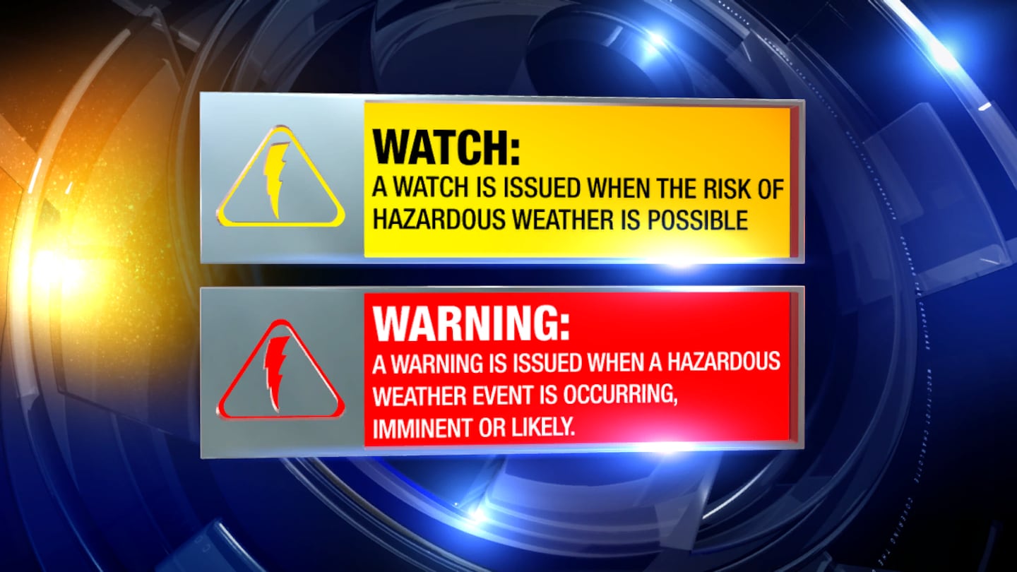
When a warning is issued, this is when you need to put your plan into action. If a tornado is in your area, get into your tornado safety place.
Channel 9 meteorologist John Ahrens spoke with Patrick Marsh, with the Storm Prediction Center, who said the historic winter is making for a bad situation.
"It's really going to be noticeable how different this year will be compared to previous years," Marsh said.
The Storm Prediction Center is responsible for issuing watches and warnings across the country.
In the case of a tornado, safe locations include:
- Lowest level of the structure
- Inside an interior room away from doors and windows
- Evacuate a mobile home and into a sturdy structure
- If you are in a vehicle or a place with no shelter available, find a low-lying area or ditch, lay down and protect the back of your head and neck
"The fact that it has been so warm across the southeast, you put strong shear on top of it and you are in business. You can see some pretty intense storms,” Marsh said.
More big bursts of energy in the jet stream are firing up one storm after another.
"At least in the short term i don't see any reason for this to change,” Marsh said.
Make sure you follow our team of meteorologists on social media to know when our next chance of severe weather may occur in the Carolinas.

To prepare for the upcoming severe weather season, North and South Carolina will run a statewide tornado drill on Wednesday. Expect to hear the sirens, and practice your safety plan at 9 a.m. in South Carolina, and 9:30 a.m. in North Carolina.
More weather resources:
- INTERACTIVE RADAR: http://on.wsoctv.com/2ijzfo1
- DOWNLOAD WSOC-TV WEATHER APP: http://on.wsoctv.com/2i0g4Sy
- HOUR-BY-HOUR FORECAST: http://on.wsoctv.com/2hYjxhn
Cox Media Group
/cloudfront-us-east-1.images.arcpublishing.com/cmg/LH3JSJEF3VBLRJLJQESEAG34AM.png)