CHARLOTTE, N.C. — The National Weather Service in Greenville-Spartanburg South Carolina confirmed a tornado southwest of Monroe in Union County.
This tornado touched down just north of the state line and tracked northeast for over seven miles.
Most of the damage was to trees but a few structures were damaged.
The most significant structure damage was to a barn that had the sides and much of the roof torn off.
Clean-up activities are under way North Carolina after tornadoes hit the state for a second day.
[READ MORE: NWS to assess storm damage Thursday in Union County]
At least four people were hurt in the storms in Iredell, Davie, Yadkin, Stokes and Union counties Wednesday.
More than 700 people were without electricity Thursday and dozens of homes were damaged as the storms knocked over trees and power lines.
(WATCH: Wall cloud forming in Statesville)
At least two mobile homes were destroyed in Iredell County. Video showed numerous trees toppled and there were several reports of property damage near the Davie County line.
The strong storms snapped trees throughout the area, and Channel 9 even found an enormous tree that split into pieces, dragging power lines to the ground.
(Click play to see damage to houses in Iredell County)
The strong winds also peeled roofs off houses, and from Chopper 9 couches and tables could be seen from the inside of the homes.
Most of the damage was concentrated within a three-mile radius of Cool Springs.
(Click PLAY to watch SkyDrone9 over Iredell County damage)
In Statesville, a tree fell onto a mobile home after powerful winds drove it right into a power pole. Metal was also stripped from buildings and wrapped around trees after mobile homes were ripped apart.
Some of the trees blocked local roads, and power lines were down as well as debris was scattered in the storm's wake.
[THURSDAY FORECAST: Temps cool into low 70s after severe storms clear out]
While many are grateful to have survived the close call, they're devastated by the damage.
"It came down like slow motion and as you can see, it just missed my place because, it was so close,” said Mike Lamoureux. “I'm sorry, I'm still shaking.”
The National Weather Service reported a storm with rotation was spotted Wednesday evening near Troutman, south of Statesville, and moved east toward Cool Springs.

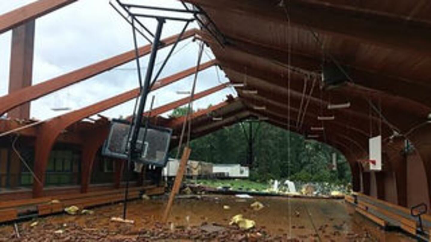
The gym at Courtney Elementary School in Yadkin County lost its roof and two walls. Emergency Management director Keith Vestal said about two dozen students and teachers took cover in the school next to that gym. None were hurt.
[PHOTOS: Tornado damage in small eastern NC town]
The National Weather Service confirmed tornadoes in Yadkin and Stokes counties and will have teams on the ground Thursday in Iredell and Union counties.
The Stokes County sheriff reported a tornado touched down there about 4:15 p.m. Fallen trees blocked roads and damaged cars, officials said.
[IMAGES: Damage on Swann Road in Iredell County]
The severe weather outbreak began in eastern North Carolina, when a tornado caused damage in Autryville.
North Carolina Gov. Roy Cooper spoke Wednesday with Autryville Mayor Larry Autry about the damage the town sustained. Autry told the governor that state Emergency Management officials have contacted him about helping.
A state of emergency was in effect for Autryville after the tornado with winds of 110 mph damaged the fire station and several mobile homes Tuesday.
Sampson County Sheriff Jimmy Thornton said one man was treated by emergency personnel after suffering minor injuries when a mobile home overturned. Thornton said all other injuries were scrapes and bruises.
(Click PLAY to see damage seen from above in Chopper 9)
Storms cause damage in central South Carolina
Residents in central South Carolina are cleaning up after storms moved across the state.
The National Weather Service confirmed two tornado touchdowns Wednesday afternoon in Saluda and Newberry counties. Forecasters planned to visit both counties Thursday to determine how long the tornadoes were on the ground and the strength of the winds.
No serious injuries were reported.
Meteorologist Doug Anderson said a storm that touched down west of Saluda shortly before 3 p.m. moved Prosperity in Newberry County a few minutes later.
Saluda County officials said some trees were down and one home was damaged.
The Newberry County Sheriff's Office said downed trees and power lines closed several roads. At least six homes were damaged.
More than 300 customers were still without electricity Thursday morning.
EF-2 tornado confirmed in Yadkin, Davie counties
Survey teams have confirmed an EF-2 Tornado crossed into Yadkin County from Davie County, the National Weather Service confirmed on Thursday.
County officials said a gymnasium lost two of its walls during Wednesday's tornado. There were also reports of several vehicles flipped and property damage to homes.
Reports said people in the Courtney General Store in Yadkinville said residents locked themselves inside a bathroom and heard noises that "sounded like a train."
The sheriff in Stokes County reported a tornado touched down around 4:15 p.m.
___
UPDATES:
4:45 p.m.
Local reports indicate a possible tornado has caused serious property damage in Iredell County.
There were reports of at least two mobile homes that have been destroyed in a portion of Iredell County near U.S. Highway 64.
Numerous trees have been toppled and there are multiple reports of property damage near the Davie County line. Some of the trees blocked local roads, and power lines were down as well.
The National Weather Service reported a storm with rotation was spotted near Troutman, south of Statesville, and moved east toward Cool Springs and the intersection of three counties near Interstate 40.
___
5:01 p.m.: Tornado Warning expires for Burke and McDowell counties.
4:59 p.m.: Thunderstorm Warning for Richmond County extended until 5:45 p.m.
[IMAGES: Severe storms roll through Charlotte area]
4:45 p.m.: Tornado Warning expired for Mecklenburg, Cabarrus, Lancaster, Rowan, Union counties.
4:30 p.m.: Tornado Warning canceled for Iredell County.
4:25 p.m:
Tornado Warning issued for Burke and McDowell counties until 5 p.m.
4:17 p.m.: Tornado Warning issued for Union County until 4:45 p.m.
(WATCH: Funnel cloud forms on Tom Greene Road in Union County)
4:12 p.m.: Thunderstorm Warning for Anson and Richmond counties until 5:15 p.m.
4:05 p.m.: Severe Thunderstorm Warning for Mecklenburg and Cabarrus counties until 4:45 p.m.
3:49 p.m: Tornado Warning in Lancaster County until 4:30 p.m.
3:30 p.m.: Tornado Warning issued for Rowan and Iredell counties until 4:45 p.m.
___
Tree down on I-77 southbound near Nations Ford Road
A tree was reported down on Interstate 77 southbound near Nations Ford Road. Crews are asking people to avoid the area and find alternate routes.
Traffic is at a complete stop.
___
House collapses in Iredell County with reports of people trapped
A house has collapsed on Swann Road in Iredell County with reports of people trapped inside, according to officials.
Numerous trees knocked down from possible tornado, sheriff's deputies said.
Channel 9 reporter Dave Faherty is headed to the scene.
___
2,500 lose power in Mecklenburg County
More than 2,500 people lost power in Mecklenburg County after storms made a path through Wednesday afternoon, Duke Energy officials said.
___
Tracking severe storms
We are tracking storms across the area that will continue through the evening hours. Some of those storms could be capable damaging wind and hail, and a there is a low tornado threat.
There will be heavy rain in these storms which will make for a messy evening commute.
[Tornado safety: The difference between watch, warning]
(MUST SEE: Funnel cloud on Plyler Mill Road in Union County)
Storms wind down later around 8 p.m., but we could still see a few lingering showers and storms overnight that won't have as great a risk of severe weather.
The NOAA weather alert radios were down for the Piedmont and the Northern Foothills for several hours Wednesday, so the only way you could have gotten severe weather alerts was by downloading our free WSOC-TV Weather app.
These radios provide critical severe weather information from the National Weather Service when Watches and Warnings are present. They will sound alarms when warnings take place so you can take immediate action.
Download the WSOC-TV weather app which does have an alarm sound and will notify you when Severe Weather is approaching.
Thunderstorms will continue firing up through the afternoon and evening hours. Threats include strong wind, heavy rain, frequent lightning and an isolated tornado. Storms will linger through the evening, clearing after midnight.
(Click PLAY for 5 severe weather hacks to get ahead of the storm)
Read more top trending stories on wsoctv.com:
- North Carolinians cleaning up after possible tornadoes hit 4 counties
- VIDEO: Severe storms, possible tornadoes slam North Carolina
- CMS approves all student assignment boundary change proposals
- Lawyer recorded telling rape victim Trump will deport her if she testifies
- More than 60 firefighters battle 3-alarm business fire in north Charlotte
- WATCH: Keith Monday's Thursday morning forecast
Cox Media Group
/cloudfront-us-east-1.images.arcpublishing.com/cmg/LH3JSJEF3VBLRJLJQESEAG34AM.png)


