QUICK HITS:
- Winter Storm Warnings in effect until Monday
- Gov. Roy Cooper issued State of Emergency for North Carolina
- Gov. Henry McMaster declared State of Emergency for South Carolina
>> We want to see what’s happening in your neighborhood. You can submit pictures and videos by clicking here.
>> Watch Channel 9 NOW for team coverage as we track weather conditions across our area.

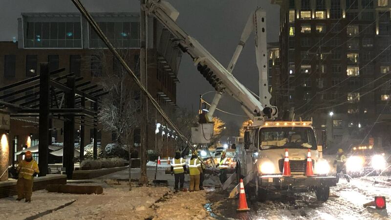
A dangerous winter storm combining high winds and ice was swept through the Carolinas on Sunday, knocking out power, felling trees and fences and coating roads with a treacherous, frigid glaze.
Winter Storm Warning - until 8 a.m. Monday:
- Alexander
- Iredell
- Catawba
- Rowan
- Cleveland
- Lincoln
- Gaston
- Mecklenburg
- Cabarrus
- Union
- York
Winter Storm Warning- until 7 a.m. Monday:
- Ashe
- Watauga
Winter Storm Warning- until 6 p.m. Monday:
- Avery
Winter Storm Warning until 8 a.m. Monday:
- Caldwell
- Burke
>> Click here to see photos Channel 9 viewers have shared of the winter weather.
Scroll below for the latest winter storm updates:
9:25 p.m.
All outages have been restored as of 5:55 p.m. for Blue Ridge Energy customers.
9 p.m.
Lost Power? @DukeEnergy maps currently show more than 51,000 outages in the Carolinas (NC = 33,250 : SC = 18,373) ; about 9,000 outages in the #CLT area. To report an outage or downed power lines, call 1-800-769-3766. Also to report an outage, you can text "OUT" to 57801 @wsoctv
— Erica Bryant (@EricaExclusive) January 17, 2022
6:30 p.m.
More than 1,800 NCDOT employees in 1,200 trucks applied nearly 10,000 tons of salt while plowing essential routes by 3 p.m. Sunday.
6 p.m.
CMPD reports 53 wrecks Sunday.
5:30 p.m.
- Charlotte Douglas International Airport remains open.
- Flight cancelations continue throughout this evening and tonight. American Airlines, which operates 90% of CLT flights, has canceled all departing flights today and more than 100 flights for Monday.
- Travelers are advised to check with their airline for information on cancelations, delays or rebooking before coming to the Airport.
5 p.m.
Huntersville: An emergency shelter is now open at Hopewell High School for anyone needing a warm, safe place. The shelter has heat, power, and basic meals. Pets are allowed.
4:40 p.m. snow totals:
The snow drought in Charlotte is over! officially 2.1" of snow/sleet! First time over one inch in just under FOUR years! How much did you see? #snOMG #ncwx #scwx pic.twitter.com/H8Ul6KeUZ5
— Steve Udelson (@SUdelsonWSOC9) January 16, 2022
4:15 p.m.
With the steady snow/sleet/rain departing our next issue is road temps - they will tank overnight and everything on them re-freezes - driving tomorrow am, while bright and sunny will be tough #ncwx #scwx pic.twitter.com/31BMpXlmwH
— Steve Udelson (@SUdelsonWSOC9) January 16, 2022
3:30 p.m.
City of Albemarle Waste Management will not have service tomorrow (Monday, January 17th) due to inclement weather. Waste Management plans to resume normal operations Tuesday on a one-day delay.
3:10 p.m.
CityLYNX Gold Line service is suspended for the remainder of the day due to inclement weather. pic.twitter.com/8M8dnyoBCa
— CATSRideTransit (@CATSRideTransit) January 16, 2022
3 p.m.
Duke Energy reported 10,000 customers were without power in the Charlotte area.
About a little over 10K without power so far in the #CLT area https://t.co/f55FLn87XW
— John Ahrens (@JohnAhrensWSOC9) January 16, 2022
2:18 p.m.
Power just came back on moments ago in downtown Waxhaw where about 2000 customers were without power. We just saw two Duke energy trucks in the area and moments later the lights here in downtown Waxhaw came back on. @wsoctv pic.twitter.com/UyJusqTz9F
— Genevieve Curtis (@GenevieveWSOC9) January 16, 2022
2:14 p.m.
Since midnight, 41 crashes have been reported across the Charlotte area, according to city officials.
Since midnight:
— City of Charlotte (@CLTgov) January 16, 2022
41 crashes
25 property damage only
16 personal injury
It’s imperative that we all stay off the roads unless absolutely necessary. @CMPD @CharlotteDOT https://t.co/aWrzUwT6kS https://t.co/ZQIOvu2jz5
2 p.m.
Watch Chief Meteorologist Steve Udelson’s latest forecast update below.

1:48 p.m.
Landscaping crews are working to clear parking lots and sidewalks here in Huntersville @wsoctv @WSOCWeather pic.twitter.com/6RuNPrByn9
— Joey Williams (@JWilliamsWSOC09) January 16, 2022
1:41 p.m.
UPDATE: A look at the crash I-77 SB between WT Harris & Sunset Rd. that is in the middle of the interstate #clt #clttraffic #cltraffic pic.twitter.com/ErmJARLuhK
— Traffic Team 9 (@TrafficTeam9) January 16, 2022
1:35 p.m.
Gov. Roy Cooper activated 224 North Carolina Army National Guard Soldiers on Saturday to help local authorities’ response to the winter storm.
Soldiers will be staged at NC Guard readiness centers in Raleigh, Morrisville, Greensboro, Charlotte, Asheville and North Wilkesboro. Some are also helping State Highway Patrol, the Department of Transportation and local authorities as needed.
1: 27 p.m.
Icy mix continues for now across the area, but some warmer air to the south should start to change over to plain rain as temps go up slightly above freezing. We could see one last burst of snow this evening with the last batch. Icy conditions return tonight as temps crash again. pic.twitter.com/zo4Z3JXKy1
— Keith Monday (@kmondayWSOC9) January 16, 2022
1:20 p.m.
4 emergency shelters are opening in Mecklenburg County @wsoctv pic.twitter.com/ABrJBcJfnG
— Joe Bruno (@JoeBrunoWSOC9) January 16, 2022
1:08 p.m.
Channel 9′s Gina Esposito learned a MEDIC truck was involved in a crash on South Tryon Street near Sandy Porter Road. She said no one was hurt in the crash.
ALERT: @GinaWSOC9 says medic involved in a crash on S. Tryon at Sandy Porter. We are happy to report everyone is ok. Please stay off the road so our first responders can stay safe! #clt #clttraffic #cltraffic pic.twitter.com/9wIsHJb0Z1
— Traffic Team 9 (@TrafficTeam9) January 16, 2022
12:52 p.m.
Here's a preliminary look at some of the freezing rain totals. Worst of the ice has definitely been in SC! @wsoctv #scwx #ncwx pic.twitter.com/VqcmsnZoC8
— Ashley Kramlich (@AshleyKramlich) January 16, 2022
12:22 p.m.
Vehicles are losing control and getting stuck on the roads. This SUV got stuck on Ashley Rd near Wilkinson Blvd. Thanks to the public works crew who came and plowed the roadway soon after. @wsoctv pic.twitter.com/cRH1ly4xyr
— Erika Jackson (@ErikaWSOC9) January 16, 2022
12:00 p.m.
Watch Meteorologist Keith Monday’s latest forecast update below.

12:00 p.m.
Gov. Roy Cooper held a news conference Sunday as North Carolina is hit with snow and ice from the winter storm.
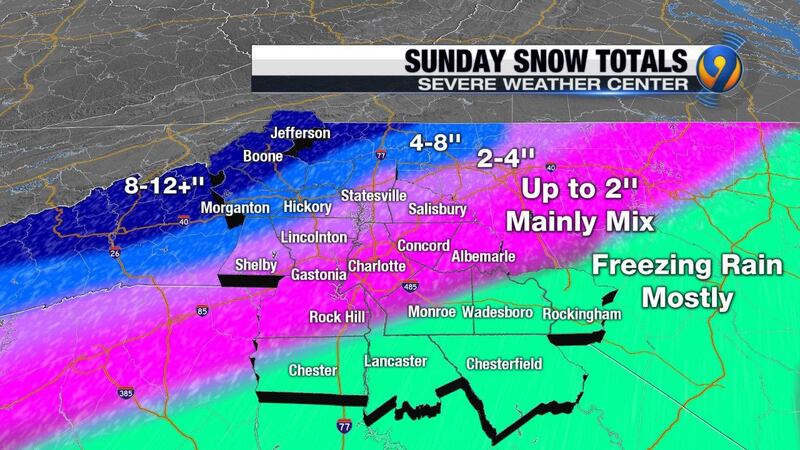
He said as much as 8-12 inches of snow has fallen in some counties, and ice is causing trouble in the central part of the state.
Conditions remain dangerous in many areas, and Cooper reminded people to stay off the roads. There have already been several crashes reported in the Charlotte area alone.
“Fewer people on the road means fewer car crashes, plus it allows highway crews and utility workers to get faster results. If you must travel, reduce your speed, increase your following distance and be sure to clear all the snow and ice off your vehicle before traveling,” Cooper said.
The governor also said ice and wind have cause power outages across the state. Locally, we haven’t seen too many outages, but more than 41,000 homes and businesses were reported without power statewide as of noon Sunday.
Utility companies continue working to get power back on in impacted areas as soon as possible.
Some counties have also opened or are preparing to open shelters for people who are without power and heat. You can find a listing of open shelters at ReadyNC.gov.
If your power goes out and you’re trying to stay warm at home, remember to keep generators outside and away from open windows or doors to prevent carbon monoxide poisoning. Never burn charcoal indoors or use a gas grill indoors.
— Governor Roy Cooper (@NC_Governor) January 16, 2022
11:47 a.m.
You can hear the wind howling here in Concord. Police just closed the flyover bridge for the Concord Mills Mall saying it’s too icy for drivers right now. @wsoctv pic.twitter.com/lCKJeLjZ2z
— Anthony Kustura (@AnthonyWSOC9) January 16, 2022
11:38 a.m.
Concord Mills will be closed Sunday, January 16th due to inclement weather. @wsoctv @WCCBCharlotte @SpecNews1CLT @fox46news @WBTV_News pic.twitter.com/YM7Ka1FEWN
— Concord Mills (@ConcordMillsNC) January 16, 2022
11:25 a.m.
In an updated winter weather advisory, Charlotte Douglas International Airport said the majority of airlines canceled flights Sunday. At this time, the airport remains open.
The airport said its snow teams were activated Saturday night and they have deiced five planes so far.
Currently, two of the airport’s three parallel runways are open.
Roads, overpasses and parking lots at the airport continue to be cleared, and plowing and deicing of the airfield are in progress.
For the latest information on delays and cancellations, click here.
11:18 a.m.
11:00 a.m.
Watch Meteorologist Keith Monday’s latest forecast update below.

10:55 a.m.
Mecklenburg Emergency Medical Services Agency says it has responded to six crashes so far Sunday.
MEDIC is advising drivers to stay off the roads as they are slippery due to freezing rain.
10:51 a.m.
SCDOT crews are plowing snow and ice in York County today. If you don’t have to be on the roads today, we urge you to not travel. Please be cautious of de-icing operations and reduce your speed. #winterweather pic.twitter.com/a0tWjk6B3Q
— SCDOT (@SCDOTPress) January 16, 2022
10:14 a.m.
RADAR UPDATE: The ice (sleet & freezing rain) has been falling across the #Charlotte metro for hours now. Freezing rain has really been accumulating over Highway 9 from Chester - Lancaster. Roads will only get worse throughout the day #ncwx #scwx pic.twitter.com/vnafSaZatH
— Ashley Kramlich (@AshleyKramlich) January 16, 2022
10:06 a.m.
Some of the strongest winds we will see from this system are moving in right now. Gusts could top 40 mph and concerns for power outages will grow. pic.twitter.com/nDTSfOE9qH
— Keith Monday (@kmondayWSOC9) January 16, 2022
10:02 a.m.
10 a.m.
Watch Meteorologist Keith Monday’s latest forecast update below.

9:55 a.m.
The winter storm continues across our area with an icy mix in Charlotte and heavy snows in the mountains. More freezing rain is likely in Charlotte and points south through the morning. My bigger concern for power outages is in SC right now. pic.twitter.com/Bc2qUxIP4L
— Keith Monday (@kmondayWSOC9) January 16, 2022
9:50 a.m.
The mayor of the City of Newton declared a state of emergency due to the winter weather conditions.
9:09 a.m.
Channel 9′s Gina Esposito said ice is starting to stick to trees in Chester County.
Ice sticking to the trees in Chester County. We’re in Richburg. @wsoctv @kmondayWSOC9 pic.twitter.com/KBRwNuArBE
— Gina Esposito (@GinaWSOC9) January 16, 2022
9:00 a.m.
Watch Meteorologist Keith Monday’s latest forecast update below.

8:50 a.m.
Channel 9′s Anthony Kustura is in Concord with the latest weather conditions.
8:09 a.m.
Meteorologist Ashley Kramlich has the latest inches of snow accumulation across the Charlotte area.
Here's some reported snow totals as of 8 AM this morning! @wsoctv #CLT #ncwx #scwx pic.twitter.com/o6Mq0mksDg
— Ashley Kramlich (@AshleyKramlich) January 16, 2022
8:00 a.m.
Watch Meteorologist Keith Monday’s latest forecast update below.

7:53 a.m.
Quite the wintry scene over Uptown this morning. Now we are seeing more ice on top of that light snow. pic.twitter.com/19aciZb57F
— Keith Monday (@kmondayWSOC9) January 16, 2022
7:43 a.m.
Channel 9′s Gina Esposito is traveling down Interstate 77 and said the road is icy near Exit 160.
NOW: I-77 near 160 exit. Yikes. Take it slow. @wsoctv pic.twitter.com/ptUu9zYZPf
— Gina Esposito (@GinaWSOC9) January 16, 2022
7:05 a.m.
As expected the travel impacts are growing. Expect major travel problems in and around Charlotte. pic.twitter.com/qoe3YOP0sz
— Keith Monday (@kmondayWSOC9) January 16, 2022
7:00 a.m.
Watch Meteorologist Keith Monday’s latest forecast update below.

6:55 a.m.
Channel 9′s Gina Esposito is tracking weather conditions in Indian Land, South Carolina.
6:07 a.m.
Channel 9′s Gina Esposito is in York County and said roads are starting to get icy.
Now: HY 161 leaving York… icy!! Be careful out there. @wsoctv @AshleyKramlich @kmondayWSOC9 pic.twitter.com/567SebIMPf
— Gina Esposito (@GinaWSOC9) January 16, 2022
6:05 a.m.
Snow is picking up in the Charlotte area, with an expected accumulation of 1 to 2 inches.
Even though it's still dark this morning, you can easily see the snow picking up in the city for now. A quick accumulation of an inch or two is possible in this batch before it changes to sleet and freezing rain. pic.twitter.com/m4KlPVbNqz
— Keith Monday (@kmondayWSOC9) January 16, 2022
5:35 a.m.
Charlotte Douglas International Airport has issued a second winter weather advisory for passengers.
The airport remains open, although airlines cancelled over 1,000 flights scheduled for Sunday.
Airport officials said deicing trucks are on standby if needed by the airlines.
The airfield, airport roadways, overpasses, and parking lots were retreated for snow and ice overnight.
They recommend passengers check with their airline for any cancelations or delay before heading to the airport.
Visit our website to view CLT’s winter weather advisory #2. https://t.co/STLhyEMEbM pic.twitter.com/6gbMizbEMZ
— CLT Airport (@CLTAirport) January 16, 2022
5:30 a.m.
Meteorologist Keith Monday said some areas with snowfall are already starting to mix with sleet and freezing rain.
Some areas are already starting to mix with sleet and freezing rain. This will eventually take over as the morning rolls on. Best advice, just stay home. pic.twitter.com/lGQqtlhu6c
— Keith Monday (@kmondayWSOC9) January 16, 2022
5 a.m.
Our Channel 9 team is LIVE throughout the Carolinas as the winter storm is underway.
4:30 a.m.
Areas of South Carolina are already seeing heavy snowfall. The Charlotte area is seeing light snow mixed with sleet that is expected to change over to ice throughout the morning.
Radar Update: Heavy snow falling over N. Chester and much of York County. Light snow mixed with sleet is falling over the CLT metro. Meanwhile sleet & freezing rain are coming down from Chester-Monroe-Albemarle east. Expect the snow for the metro to changeover to ice thru the AM pic.twitter.com/CFo7ndz7v0
— Ashley Kramlich (@AshleyKramlich) January 16, 2022
4:15 a.m.
Our winter storm is here and Severe Weather Center 9 said conditions will go downhill quickly this morning. Meteorologists Ashley Kramlich and Keith Monday have the latest update.
4:00 a.m.
Meteorologist Keith Monday gives the latest forecast as snow continues to fall across the state.

2:30 a.m.
Snow has started to fall. Severe Weather Center 9 will keep us updated as the snow turns to sleet and ice throughout the morning.
Storm alerts remain the same across the region for today and into this evening. Snow is starting now, but will change over to sleet and then freezing rain as we head through the morning. Conditions will just continue to go downhill through the day. pic.twitter.com/t9Hal9udoo
— Keith Monday (@kmondayWSOC9) January 16, 2022
The snow has begun in Charlotte. Sure wish it was going to stay this way all day, but unfortunately more ice concerns grow as the day goes on. pic.twitter.com/V2yI4DTysc
— Keith Monday (@kmondayWSOC9) January 16, 2022
SUNDAY OUTLOOK
- The winter storm is unfolding Sunday morning.
- Temperatures are going to hover just near freezing throughout the day.
- Some of that will be freezing rain, not snow, in the Charlotte area.
- With freezing temperatures, the rain freezes on contact with the ground, creating icy conditions.
- We could see light snow Sunday evening.
- The sleet and freezing rain will continue to accumulate through the day and could be as much as a half an inch. This has the possibility to cause widespread damage to trees and powerlines across our area.
- North of Charlotte, residents can expect higher snow totals, but sleet is likely to still be mixed in.
- The northern foothills and mountains will have the greatest snow accumulation, possibly as much as six inches.
- South of Charlotte, an elevated area of warm air will be strong enough to melt the rain as it comes down, only to have it freeze right on the road when it lands. That’s freezing rain and the levels could be extremely high, creating the greatest threat for power outages.
- By Sunday afternoon, 90% of the roads will be icy. As the afternoon progresses, the roads are expected to be worse.
- Most of this will come to an end by Sunday evening, but impacts could last several days.
- Temperatures will not rise above freezing until Monday afternoon.
- On Monday afternoon, the ice will start to melt.
- Any ice that doesn’t melt will refreeze Monday night into Tuesday morning.
- Be prepared for several days of impact!
NCDOT crews get Charlotte area roads ready
NCDOT brought in workers from other departments to be part of the 133 crews using 288 trucks to take care of more than 2,000 miles of roads. They used as much as 125,000 gallons of brine on Charlotte roads Friday.
“Our response may not be as quick as what you’ve seen in the past,” said Jen Thompson, spokesperson for NCDOT. “But we are putting every effort out there and we are putting all available, healthy hands out there to clear the roads and to treat the roads, and we are not going to lessen our efforts until we clear every road.”
Duke Energy estimates 750K customers could lose power - Jan.15
Duke Energy announced Saturday that it estimates 750,000 customers could lose power across the Carolinas due to the winter storm.
Hundreds of utility trucks lined the parking lot at Charlotte Motor Speedway as power crews brace for the worst, while hoping for a different outcome.
The company has more than 10,000 response workers on standby to start restoring power once the weather permits. Crews have also come from different states across the country like Texas, Florida, and Ohio.
McMaster declares State of Emergency- Jan.14
McMaster declared a state of emergency Friday as South Carolina workers spent the day getting state roads ready for the storm -- particularly preparing for ice.
Crews are very concerned about the combination of ice and wind expected to hit many of Channel 9′s South Carolina counties, and they are begging everyone to be prepared.
The state’s Department of Transportation crews have been mixing brine and spent all day Friday spraying it on the roads, hoping to lessen the impact of the storm.
Cooper declares State of Emergency- Jan. 13
The governor signed a state of emergency Thursday evening to activate state resources to respond to the storm and to allow for the possibility of Federal reimbursement if the event qualifies.
NCDOT crews and contractor resources have been working to clear roads as fast as possible, but response times are expected to be slower than previous storms due to labor shortages impacting crews spread around the state.
Department of Transportation workers started brining roads Thursday in preparation for the storm.
Transportation officials recommend staying off the roads once travel conditions deteriorate.
Winter Weather Guide:
- View current school, business closings
- View our Interactive Radar
- Sign up to receive severe weather closings text alerts
- Winter weather watch, warning and advisory: What’s the difference?
- What you need to know if you’re traveling in winter weather
- How to be prepared for this weekend’s snow storm
- 7 tips to keep your pets safe during winter weather
- Download WSOC-TV Weather App
- Sign-up for Closing Alerts
- Current Weather Closings
- FOLLOW WSOC-TV Weather on Twitter
- LIKE WSOC-TV Weather on Facebook
(WATCH BELOW: Duke Energy estimates 750K customers could lose power across Carolinas due to winter storm)

©2022 Cox Media Group
/cloudfront-us-east-1.images.arcpublishing.com/cmg/LH3JSJEF3VBLRJLJQESEAG34AM.png)


