
>> Reading this story in our app? The new "Follow the Lead" feature allows you to tap the blue tag indicated with a '+' to subscribe to alerts on the very latest severe weather updates.
>> Download our WSOC-TV app and keep up with winter weather conditions wherever you go.
>> Remember, you can watch our radar anytime at home on Roku, Amazon Fire and Apple TV.
The threat of winter weather is preparing to bear down on the Charlotte region and we are here to make sure you are prepared.
[WINTER WEATHER OUTLOOK: Channel 9 meteorologists prepare you for the season ahead]
[SPECIAL SECTION: Winter Weather Guide]
While the storm is still hundreds of miles away, the impacts we will see closer to the Queen City are starting to come into focus.
We can expect the storm to make its way into our area late Saturday night and into Sunday morning.
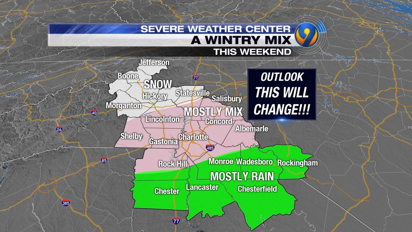
It is expected to be a wintry mix with the highest impact area from Interstate 40 to the north.
Right now, it looks like the mountains will see the brunt of this system, but anywhere north of Interstate 85 could see accumulating snow.
There are still unknowns about this winter storm, such as how long it will last, the exact track, and the depth of cold air.
Channel 9 reporter Dave Faherty was in the mountains on Wednesday and saw heavy snow falling across the region.
In Boone, several secondary roads were being closed because of the wintry conditions, and some drivers were having trouble on the slick roads.
In Blowing Rock, snow was falling fast along Highway 321, where roads were wet but not covered. School is closed Thursday in Watauga and Avery counties. Ashe county is operating on a 2-hour delay.
[CLICK HERE for closings and delays]
Severe Weather Center 9's team of meteorologists is keeping a close eye on this storm system, mapping out the latest timeline and tracking what impacts you may see in your neighborhood.
FOLLOW OUR TEAM ON TWITTER:
- Chief Meteorologist Steve Udelson
- Meteorologist Keith Monday
- Meteorologist John Ahrens
- Meteorologist Jaclyn Shearer
- Meteorologist Tony Sadiku
Big snows in December are not typical for the Charlotte region.
According to Meteorologist Keith Monday, Charlotte averages 4 inches of snow per year and averages 0.3 inches in December.
Monday said most of our big snows come in January or February.
The last time the Charlotte region had an accumulating snow in December was in 2010 when the area received 2 inches of snow.
In the early 1970s, Charlotte received 5 inches or more in December. This was considered the last big snow for the Charlotte region.
Posted by Dave Faherty on Wednesday, December 5, 2018
To get ready for winter weather, North Carolina Emergency Management officials urge you to:
- Store an emergency kit in your vehicle. Include scraper, jumper cables, tow chain, sand/salt, blankets, flashlight, first aid kit and road map
- Always keep at least a three-day supply of non-perishable food in your home
- Keep fresh batteries on hand for weather radios and flashlights
- Properly vent kerosene heaters and keep electric generators outside and away from open windows or doors to prevent carbon monoxide poisoning. Do not burn charcoal indoors
- Use a NOAA Weather Radio or monitor local news media for changing weather conditions
- Keep alternative heating sources and fire extinguishers on hand. Be sure your family knows how to use them
- Download the ReadyNC app for more winter weather preparedness information
For more winter weather preparation tips, follow North Carolina Emergency Management or South Carolina Emergency Management on Twitter.
Winter Weather Links:
- How and when to protect your pipes from freezing
- Winter weather watch, warning and advisory: What's the difference?
- 7 tips to keep your pets safe during winter weather
- More ideas to keep kids entertained during a storm
- Bread and milk: Why do we buy those foods before a storm?
- Snow day? 5 kid-friendly craft ideas to ward off cabin fever
- Here are 16 tips for keeping you, your pets and home safe in the cold
- Tips, warning signs for frostbite, hypothermia
- When temperatures drop, don't be thrifty with your heat
- Life hacks: How to remove snow when you don't have shovels
- 7 winter driving tips
- 5 things you won't want to leave in a freezing car
- Stay safe while driving on black ice
- What is the coldest temperature ever recorded in each state?
WEATHER RESOURCES:
- Interactive Radar
- Download our weather app for Severe Weather Alerts
- Hour-by-Hour Forecast
- 7-Day Forecast
Cox Media Group

/cloudfront-us-east-1.images.arcpublishing.com/cmg/LH3JSJEF3VBLRJLJQESEAG34AM.png)


