
QUICK HITS:
- Gov. Roy Cooper issued State of Emergency for North Carolina
- Gov. Henry McMaster declared State of Emergency for South Carolina
- Black ice causing dangerous driving conditions across the Charlotte area
>> Watch Channel 9 for team coverage as we track road and weather conditions across our area.
Temperatures Monday afternoon were warm enough to melt the snow and ice left on roads from the winter storm the day before.
Black ice formed again Tuesday night as temperatures dipped well below freezing. Officials have warned to stay off the slick roads.
>>Click here for school closings in our area
>> Click here to see photos Channel 9 viewers have shared of the winter weather.
(WATCH BELOW: Monday night’s forecast update with Meteorologist John Ahrens)

>> To stay on top of changing weather conditions be sure to download our free WSOC-TV Weather app
Scroll below for the latest updates on winter weather and road conditions:
10 p.m.
Nearly 9,000 Duke Energy customers were without power in the Carolinas.
9 p.m.
Sunshine and warmer temperatures in most areas allowed roads to warm up and driving conditions to improve Monday afternoon, NWS stated in its update.
However, most areas remained wet from snowmelt.
It will be considerably colder Monday night than the night before.
Any roads that were still wet at sunset are likely to freeze over. Black ice will be a significant road hazard overnight through at least late Tuesday morning.
Stay off the roads unless absolutely necessary. Any motorists who venture out are urged to use extreme caution. If a road looks wet, it likely is covered in a thin sheet of ice.
6 p.m.
Driving weather tomorrow = #notgood pic.twitter.com/gfx8sKbGxk
— John Ahrens (@JohnAhrensWSOC9) January 17, 2022
5 p.m.
The wreck on I-85 at I-485 has cleared. One person was taken to a hospital with serious injuries.
4:50 p.m.
More winter drama ahead! Including tonight! @wsoctv pic.twitter.com/kBqoWFzURi
— John Ahrens (@JohnAhrensWSOC9) January 17, 2022
4:30 p.m.
Traffic along I-85 North in Mecklenburg County near Exit 48 continues to give drivers headaches after an afternoon wreck.
3:15 p.m.
A crash involving several vehicles closed three out of five lanes along I-85 North near I-485 (Exit 48).
TRAFFIC ALERT: A crash involving several vehicles closed three out of five lanes along I-85 North near I-485 (Exit 48).
— WSOCTV (@wsoctv) January 17, 2022
Traffic Maps>> https://t.co/geAy4xr2Rg pic.twitter.com/kQ7Xwfff2Y
3 p.m.
FORECAST UPDATE:
- Monday’s highs reached into the 40s allowing for some of the snow and ice to melt.
- Roads will freeze over again overnight leading to slick travel conditions in the morning.
- Tuesday and Wednesday will be clear with highs in the mid-to-upper-40s in the Charlotte area.
- Rain is likely Wednesday night.
- Thursday highs will be in the mid-40s with rain in the forecast.
- The potential for more wintry precipitation is in the forecast as the weekend approaches.
- One computer model has the system arrive Friday and leave Saturday.
- Another model gets here Saturday.
- “There is significant uncertainty as to what will take place by the end of the week/weekend,” Meteorologist John Ahrens said.
2:30 p.m.
Need a test today? Lanes of testing are open at Mako Medicals location at Carowinds. No wait! This is the only mass site available today.
— Genevieve Curtis (@GenevieveWSOC9) January 17, 2022
They’re here until 4pm. Back open at 8 am tomorrow. No appointment necessary. But they’re asking you to pre register. @wsoctv pic.twitter.com/Rnepf9uTOG
1:50 p.m.
Due to winter weather conditions, school district across our area are starting to announce plans and changes to classes on Tuesday.
Click here for the latest updates on delays and cancellations for local districts.
12:46 p.m.
Driving On A Sheet Of Ice
— Ken (@kenlemonWSOC9) January 17, 2022
I captured this image standing on the double yellow line in the middle of Owls Den Road in Lincoln County. It’s covered in ice. It’s one of many roads that @NCDOT and emergency officials say are not closed but are nearly impassable. pic.twitter.com/3fy1mYExRO
12:40 p.m.
Pretty This Morning, Maybe Not Tonight
— Ken (@kenlemonWSOC9) January 17, 2022
Thank you to @wsoctv viewer Mike Gibson for snapping those drone pictures of snow in @CityofGastonia They are pretty pictures this morning but tonight some roads are expected to freeze in causing hazards that are hard to see. Be careful. pic.twitter.com/3lSkmo9LJa
11:02 a.m.
Now that the clouds are clearing out, you can see the snowfall left behind from yesterday's storm. The mountains continue to see snow showers all day long with another few inches of accumulation. pic.twitter.com/MYPKyVA2DQ
— Keith Monday (@kmondayWSOC9) January 17, 2022
10:43 a.m.
As we await the CMS decision for tomorrow: This is a street in Hidden Valley last night. Many neighborhood streets look like this still. Bus/student safety on neighborhood streets is always a main factor when deciding winter weather closures. pic.twitter.com/vY3SJxVskC
— Joe Bruno (@JoeBrunoWSOC9) January 17, 2022
10:05 a.m.
OFFICIAL: Due to the inclement weather from #WinterStormIzzy, @LNCharter will be CLOSED tomorrow, January 18th. This is considered a traditional "No School for Students" day.
— Craig S. Smith (@CSmithGoBlue) January 17, 2022
We will continue to monitor conditions for potential operational impact to Wednesday.#LNCPride #nced
9:24 a.m.
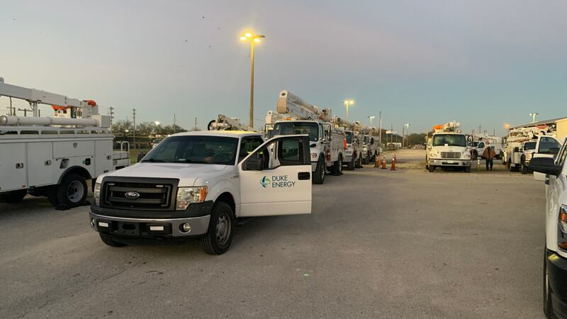
As of 9:20 a.m., around 42,000 @DukeEnergy customers are without power after the winter storm. Repairing 2,000 outage locations. Pinehurst/Carthage area, Upstate SC and western NC remaining hardest hit pockets. Thousands of workers engaged throughout the day to restore power. pic.twitter.com/82Gnb5MpEw
— Jeff Brooks (@DE_JeffB) January 17, 2022
9:19 a.m.
SouthPark and Concord Mills both opening at noon today. @wsoctv https://t.co/biG0TMIYYu pic.twitter.com/mdF1czqApd
— Michael Stolp (@StolpWSOC9) January 17, 2022
9:13 a.m.
Falling and blowing snow making for rough conditions in downtown #BooneNC https://t.co/FwFdfpNLHO pic.twitter.com/WnYWri54uZ
— WataugaOnline (@WataugaOnline) January 17, 2022
9:12 a.m.
Emergency shelters that were activated across Mecklenburg County in response to the severe weather impacting the Carolinas are being demobilized Monday.
The Charlotte-Mecklenburg Emergency Management Office, in partnership with the American Red Cross and the town of Matthews, opened four shelter locations in Charlotte, Huntersville and Matthews on Sunday, according to a release from the office.
The Hopewell High School and Crews Recreation Center locations were demobilized at 7 a.m., and the Mallard Creek High School and Central Piedmont locations will demobilized at noon.
.@CharMeckEM and partners are demobilizing the emergency shelters. Staff at Crews Recreation Center and Hopewell High demobilized at 7 a.m. as there were no residents at those locations. Shelter crews at Mallard Creek High and Central Piedmont will demobilize at noon today. https://t.co/MUWCzNTds5
— City of Charlotte (@CLTgov) January 17, 2022
8:57 a.m.
The CityLYNX Gold Line will NOT operate today (Mon. Jan. 17) due to snow and ice. https://t.co/WDBjGg1eWu
— CATSRideTransit (@CATSRideTransit) January 17, 2022
Due to heavy snow and ice, several bus routes may be experiencing slight detours. Normal routing will resume as snow is cleared. Riders can call CATS customer service at 704-336-7433 or download the CATS-Pass app for real time bus tracking.
— CATSRideTransit (@CATSRideTransit) January 17, 2022
8:31 a.m.
NOW: University City Blvd near UNC Charlotte. @wsoctv pic.twitter.com/scrl1DNKwA
— Gina Esposito (@GinaWSOC9) January 17, 2022
8:26 a.m.
TRAFFIC: Deputies are reporting secondary roads are still pretty slick. Main roads are fairly clear. As always just take your time and drive safely IF you need to get out this morning. #YCSONews #Traffic pic.twitter.com/1gugMT8Mm0
— York County Sheriff (@YCSO_SC) January 17, 2022
8:21 a.m.
A few snow showers are coming off the mountains through the northern foothills. Shouldn't last all that long, mountain snow will last most of the day though. pic.twitter.com/sb3UFergIU
— Keith Monday (@kmondayWSOC9) January 17, 2022
8:07 a.m.
New street closure notices for Charlotte are available. View additional information and new closures on the interactive street closure map. This information is updated daily. https://t.co/DEaDvClSmK pic.twitter.com/eftgChD5aU pic.twitter.com/8VE57nH3xh
— Charlotte DOT (@CharlotteDOT) January 17, 2022
8:05 a.m.
Folks, please don't go out unless you absolutely have to. Roads are still iced over in the metro and snow covered up north where they had more snow. Be smart, it's not worth it.
— Keith Monday (@kmondayWSOC9) January 17, 2022
7:42 a.m.
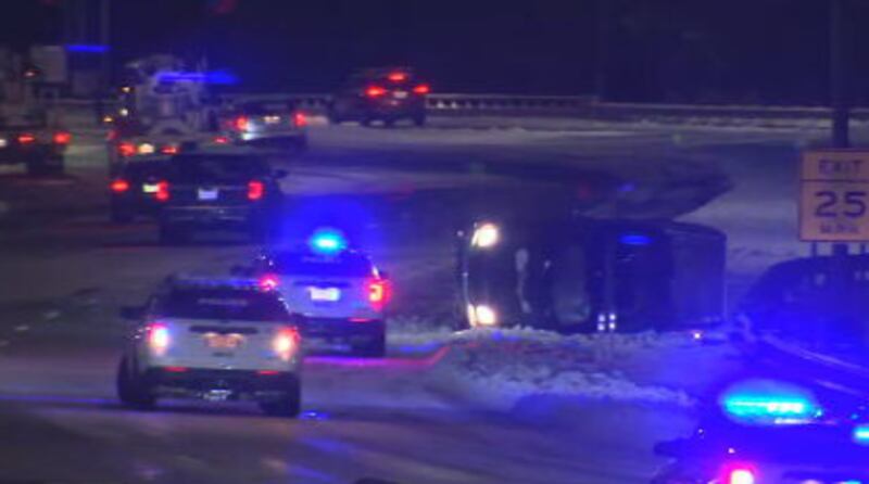
ALERT: I-77 SB is BLOCKED as crews work another overturned I-77 SB near West Blvd. #clt #clttraffic #cltraffic pic.twitter.com/Ppz9YSKcCP
— Traffic Team 9 (@TrafficTeam9) January 17, 2022
7:24 a.m.
Hickory- Public Works is back out this morning trying to clear some of the roads. I just took this cell phone video along Lenoir Rhyne Boulevard. Crews are working 13-hour shifts right now. pic.twitter.com/eF5urTNMYy
— Dave Faherty (@FahertyWSOC9) January 17, 2022
7:08 a.m.
NOW: Downtown Pineville looks pretty clear! @wsoctv pic.twitter.com/GbLRcLA7ly
— Gina Esposito (@GinaWSOC9) January 17, 2022
7:06 a.m.
Temps will slowly warm back above freezing by late morning and eventually get close to 40° this afternoon with that sunshine. Best to hold off any traveling for now. pic.twitter.com/piG9GE7keI
— Keith Monday (@kmondayWSOC9) January 17, 2022
6:48 a.m.
ALERT: I-77 is a ice rink. Multiple crashes have occurred since 4:30 AM between Remount Rd. & #uptown including this car that flipped I-77 SB at Trade St. Avoid! #clt #clttraffic #cltraffic pic.twitter.com/XdjAb6kyKZ
— Traffic Team 9 (@TrafficTeam9) January 17, 2022
6:37 a.m.
Hello Matthews! Pineville-Matthews Rd looks plowed & treated. Only tricky spots are turn lanes- those lanes haven’t been hit yet. See you in Pineville at 7am on #TV64 #waxn. @wsoctv pic.twitter.com/jNxfEuIiH1
— Gina Esposito (@GinaWSOC9) January 17, 2022
6:26 a.m.
NOW: E John St at Trade St in Matthews. I’ll be live in the area ahead at 6:30am! @wsoctv pic.twitter.com/FE2W0P88s0
— Gina Esposito (@GinaWSOC9) January 17, 2022
6:15 a.m.
ALERT: A rollover crash just occurred in the exact same spot I-77 SB ramp to Trade St. Please avoid driving this morning! #clt #clttraffic #cltraffic pic.twitter.com/tMvafAgN42
— Traffic Team 9 (@TrafficTeam9) January 17, 2022
5:54 a.m.
The winds are still howling in the mountains this morning, gusting near 60 mph at times! Still very breezy in the metro too. pic.twitter.com/Lg5grefUg8
— Keith Monday (@kmondayWSOC9) January 17, 2022
5:48 a.m.
ALERT: A crash involving a red truck carrying a generator partially blocking the ramp I-77 SB to Trade St. Still very icy especially on ramps and overpasses. Please stay home if you can. #clt #clttraffic #cltraffic pic.twitter.com/WQl4eKWvvn
— Traffic Team 9 (@TrafficTeam9) January 17, 2022
5:46 a.m.
NOW: The Plaza & Pecan Ave looked plowed and treated. #eclt We just saw a plow on 7th St. @wsoctv pic.twitter.com/Cgw7uyK84T
— Gina Esposito (@GinaWSOC9) January 17, 2022
5:36 a.m.
NOW: Took a trip over to Noda. 36th St looked plowed and treated. Side streets.. like this one still a little dicey. N Tryon looked good up to University City 👍🏽@wsoctv #nclt pic.twitter.com/dEjakyQ7jP
— Gina Esposito (@GinaWSOC9) January 17, 2022
5:17 a.m.
ALERT: Crash reported I-77 SB near Morehead St. #clt #clttraffic #cltraffic
— Traffic Team 9 (@TrafficTeam9) January 17, 2022
5:16 a.m.
NOW: Atanto -> n Tryon St. Mostly clear- still some spots that haven’t been plowed. Slushy/wet roads. @wsoctv pic.twitter.com/ixLbSBQwod
— Gina Esposito (@GinaWSOC9) January 17, 2022
5:07 a.m.
Give or take on a few locations… but our snow forecast was almost spot on yesterday. Snow forecasting in the south can be a nightmare w/ so many factors going into the forecast. I’m impressed w/ our team to say the least. Top: Our Forecast. Bottom: Observed Snow Totals. @wsoctv pic.twitter.com/6EnYKRVP6o
— Ashley Kramlich (@AshleyKramlich) January 17, 2022
5:05 a.m.
Quite the snowy scene from the Lake Norman cam early this morning. Roads are going to be very icy and slick. Our team is showing you the conditions you'll encounter and how long it takes to thaw out this week. pic.twitter.com/sROVxvYOxX
— Keith Monday (@kmondayWSOC9) January 17, 2022
4:53 a.m.
NOW: Here’s a look at Freedom Dr - looking good! Camp Greene St too 👍🏽 @wsoctv #wclt pic.twitter.com/7T2qaw8ExY
— Gina Esposito (@GinaWSOC9) January 17, 2022
4:46 a.m.
NOW: Here’s West Blvd heading into #wclt . One lane clear heading outbound. Same situation for Remount Rd. @wsoctv pic.twitter.com/il5ir8ZvLZ
— Gina Esposito (@GinaWSOC9) January 17, 2022
4:39 a.m.
NOW: Tremont Ave in Dilworth. A lot of side streets/neighborhood streets haven’t been plowed.
— Gina Esposito (@GinaWSOC9) January 17, 2022
Side note.. check out this awesome snowman ⛄️ @wsoctv pic.twitter.com/OOaUkfMIR2
4:23 a.m.
Good morning!
— Gina Esposito (@GinaWSOC9) January 17, 2022
We are driving around Charlotte to check out the road conditions. Here’s Morehead St- looking pretty good! Catch my reports starting at 4:30am! @wsoctv pic.twitter.com/4iU9wwkyve
4:15 a.m.
#BREAKING: I-77 NB prior to John Belk CLOSED due to crash involving what appears to be an overturned tractor trailer. Join us at 4:30AM for updates on @wsoctv #clt #clttraffic #cltraffic pic.twitter.com/OTX2eRiQR9
— Traffic Team 9 (@TrafficTeam9) January 17, 2022
WEATHER RESOURCES:
- Interactive Radar
- Download our weather app for Severe Weather Alerts
- Hour-by-Hour Forecast
- 7-Day Forecast
FOLLOW OUR TEAM ON TWITTER:
- Chief Meteorologist Steve Udelson
- Meteorologist Keith Monday
- Meteorologist John Ahrens
- Meteorologist Ashley Kramlich
MONDAY OUTLOOK
- Temperatures will not rise above freezing until Monday afternoon.
- With low temperatures, the rain freezes on contact with the ground, creating icy conditions. Black ice is a big threat.
- Full sunshine returns Monday, so we will warm up to near 40 degrees by the afternoon.
- Any ice that doesn’t melt will refreeze Monday night into Tuesday morning, as temps fall to below freezing overnight.
- Be prepared for several days of impact!
- Expect more sun Tuesday, and more melting with highs in the mid 40s.
- Rain chance to move in late Wednesday, but it looks like just the mountains could see some snow.
- We will watch another system on Friday that could bring another wintry mix areawide though.
Winter storm brought snow, sleet, ice to the Carolinas Sunday
A winter storm combining high winds and ice swept through parts of the U.S. Southeast on Sunday, knocking out power, felling trees and fences and coating roads with a treacherous, frigid glaze.
More than 1,800 NCDOT employees in 1,200 trucks applied nearly 10,000 tons of salt while plowing essential routes by 3 p.m. Sunday.
Tens of thousands of customers were without power in North Carolina and South Carolina Sunday evening, including 10,000 Duke Energy customers in the Charlotte area.
Highway patrols reported hundreds of vehicle crashes across the Carolinas, and Charlotte-Mecklenburg police said it responded to 53 wrecks Sunday.
The winter storm also impacted airlines, with more than 1,200 Sunday flights at Charlotte Douglas International canceled – more than 90% of the airport’s Sunday schedule, according to the flight tracking service flightaware.com.
Flight cancellations continued into Monday, with American Airlines, which operates 90% of CLT flights, canceling more than 100 flights for Monday.
Ahead of the storm, North Carolina Gov. Roy Cooper and South Carolina Gov. Henry McMaster issued state of emergencies as workers in both states spent days getting state roads ready for the storm -- particularly preparing for ice.
>> For our minute-by-minute coverage of the winter storm Sunday, click here.
(WATCH BELOW: Tens of thousands of Duke Energy customers lose power across Carolinas due to winter storm)
©2022 Cox Media Group

/cloudfront-us-east-1.images.arcpublishing.com/cmg/LH3JSJEF3VBLRJLJQESEAG34AM.png)


