NORTH CAROLINA — North Carolina is preparing for two storm systems to hit over the next week.
We’re expected to have chilly, breezy weather until the first system comes in Saturday morning, according to Severe Weather Center 9 Meteorologist Keith Monday.
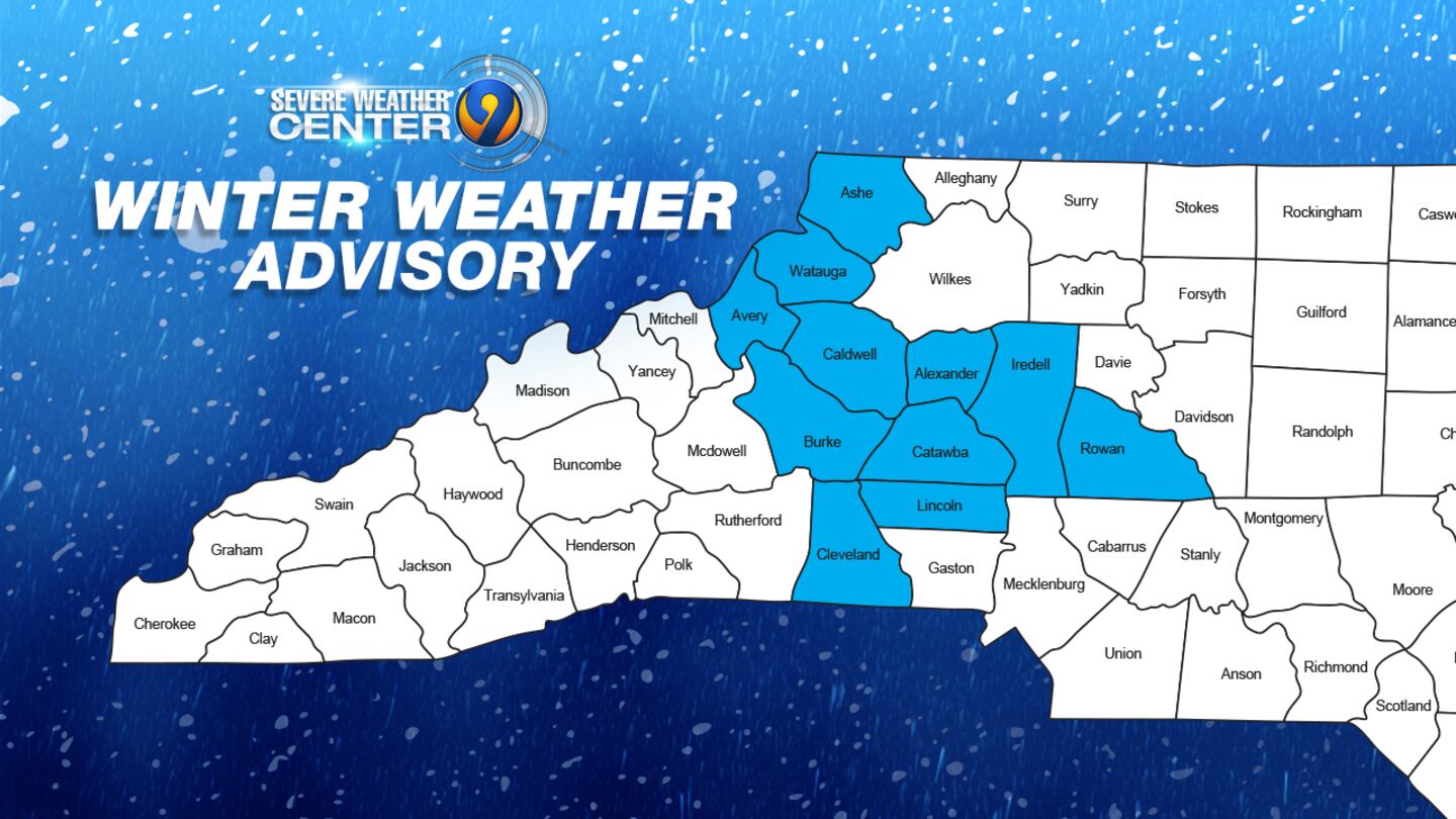
On Saturday, areas up north against the mountains -- the Foothills and Interstate 40 Corridor -- will see a brief window of freezing rain. A Winter Weather Advisory is in effect for our northern counties.
Impacts for tomorrow morning's ice potential are low for most of the area. Limited impacts in the metro with mainly just wet and cold conditions. Minor impacts (yellow) along the I-40 corridor with a little slick travel. Pockets of moderate impacts (orange) far north and west. pic.twitter.com/TcqxPsmT7x
— Keith Monday (@kmondayWSOC9) January 5, 2024
That region is expected to get a light accumulation of ice Saturday morning, which might raise minor travel concerns. The highest potential for ice will be between Hickory, Morganton, Lenoir, and Taylorsville. No other impacts are expected.
The ice could add up to between one-tenth and two-tenths of an inch.
The rest of the Charlotte area, including the metro, will just see a cold rain that moves in just after midnight Friday night. The metro is expected to see half an inch of rain.
So, not expecting a major event, but you'll want to take caution heading out on the roads early Sat. Temps warm up to thaw out through the day. Bottom line for Charlotte, it's going to be miserably cold and wet start to the weekend. This all clears out by Saturday afternoon.
— Keith Monday (@kmondayWSOC9) January 5, 2024
Temperatures may be close to freezing for a short time early Saturday, but will warm up enough to keep everything liquid. The rain will taper off by midday.
Dry weather will remain through the rest of the weekend.
Morganton- the NCDOT is making preparations for the possibility of winter weather. Plows are going on all the trucks and chainsaws are being sharpened in case there is ice. Watch channel 9 eyewitness news for updates on this weekend’s weather. pic.twitter.com/aLgw0oslSZ
— Dave Faherty (@FahertyWSOC9) January 4, 2024
A much larger storm system will come our way by Tuesday, Meteorologist Keith Monday says. It’ll just be rain, but it could be heavy and will add up.
Tuesday’s storm could be much more impactful than Saturday’s, he says.
Crews prepare

Across western North Carolina Thursday and Friday, preparations were underway by the North Carolina Department of Transportation. They’re keeping a close eye on the forecast.
The biggest concern is the six-hour window Saturday morning when temperatures could be at or below freezing.
In Burke County, road crews had plows on all the trucks by the end of the day Thursday. They prepared not only for snow, but also for the possibility of ice, sharpening their chainsaws ahead of the storm.
They also have the spreaders on a number of the trucks, along with 2,500 tons of salt.
Winter Storm Watch issued January 04 at 8:34PM EST until January 06 at 1:00PM EST by NWS https://t.co/rGpGbaU9zM
— Steve Udelson (@SUdelsonWSOC9) January 5, 2024
Channel 9′s Dave Faherty learned they are not putting down brine -- a salt and water mixture -- ahead of the storm as they are concerned it could wash away if the storms starts off as rain first Friday night.
“Make sure all of our chainsaws are sharpened,” NCDOT’s Josh Mashburn said. “We got our signs, barricades everything on the emergency truck ready to go. Our crews are lined up. We went over our safety stuff.”
At Hickory Public Works on Friday, crews were digging into their salt bins to make brine. Road crews said they’ve got plenty of it on hand after Hickory didn’t see any snow last winter.
Hickory crews focused on spraying brine on the bridges and some of the steeper hills in town on Friday. The NCDOT was also out on the major highways like I-40 and Highway 321 Friday morning.
At higher elevations west of Burke County, there could be a wet, heavy snow. Faherty saw plows placed on the trucks in that area.
Students at Lenoir-Rhyne University just came back from winter break, and they’re hoping for snow.
“It’s been pretty nice the last couple of days and I’m really hoping to get a little snow,” Matthew Stein said. “You know snow is fun.”
“I think it would be awesome,” Davis Hull said. “I haven’t gone sledding in forever. I’m from Charlotte and we never get snow down there.”
As the storm moves closer to the Carolinas, the NCDOT said it could adjust its plans. They are looking at having extra crews Friday night.
(WATCH BELOW: Several northwestern North Carolina schools operating on two-hour delay)

©2024 Cox Media Group

/cloudfront-us-east-1.images.arcpublishing.com/cmg/LH3JSJEF3VBLRJLJQESEAG34AM.png)


