CHARLOTTE — BELOW: The latest updates from Severe Weather Center 9. To stay on top of severe weather conditions, be sure to download our free WSOC-TV weather app.
10:30 a.m. — Mecklenburg County latest weather updates
- A tree is reported to be down on Guilford Road in the Sedgefield neighborhood.
- Fire crews are on scene.

10:25 a.m. — Cabarrus County latest weather updates
- The tornado warning has been lifted for Cabarrus County
10:15 a.m. — Gaston County latest weather updates
- A tree is reported to be down on Julia Avenue in Gaston County.
- Crews are on scene.
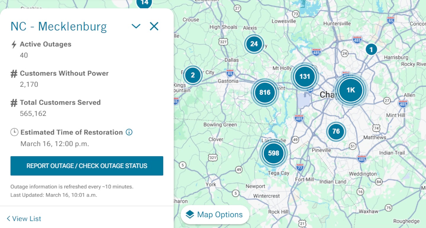
10:10 a.m. — Mecklenburg County power outages
- Duke Energy reports 40 active outages in Mecklenburg County
- 2,170 Duke customers are without power, the energy company reports
- Officials expect power to be restored by noon.
10:05 a.m. — Tornado Warning updates in Mecklenburg County
- Tornado Warning has been canceled for Mecklenburg County
10 a.m. — Tornado Warning updates in Cabarrus County
- NWS reports ongoing Tornado Warning, with the radar indicating a tornado, southeast of Concord
- Pea-sized hail is possible
- Warning continues until 10:15 a.m.
Tornado Warning continues for Concord NC until 10:15 AM EDT pic.twitter.com/9qrjuqgD39
— NWS Tornado (@NWStornado) March 16, 2026
9:45 a.m. — Tornado Warning in Mecklenburg and Cabarrus Counties
- Tornado warning issued for Mecklenburg and Cabarrus Counties, lasting until 10:15 a.m.
- Warning issued through Uptown, University City, Plaza Midwood, Newell, Druid Hills, NoDa, and Concord areas.
9:05 a.m. — Latest updates on incoming thunderstorms, possible tornadoes
- Tornado watch issued for Richmond, Stanly, and Anson Counties.
- Severe Thunderstorm warning issued for Mecklenburg, Cabarrus, Gaston, and Lincoln Counties.
A Tornado Wwarning has been issued for the highlighted area. If you are located within this warning, seek shelter now. More info at https://t.co/ticb9BnUvO pic.twitter.com/MxBBUV28RY
— Danielle Miller (@wx_danielle) March 16, 2026
9 a.m. — Latest updates at Charlotte-Douglas International Airport
- The FAA issued a second ground stop of the day at CLT
- The stop is effective starting at 8:30 a.m., continuing until at least 10 a.m.
- Officials say the stop was issued due to thunderstorms, with a chance of the stop being extended.
CharMeckALERT: EXTREME WIND & TORNADO RISK TODAY
— Charlotte-Mecklenburg Emergency Management (@CharMeckEM) March 16, 2026
Charlotte-Mecklenburg is at extreme risk for severe winds and possible tornadoes today. Wind gusts may be up to 30 mph throughout the day.
Remember:
If a tornado WATCH is issued, find your "safe space". Look for an interior room…
9 a.m. — Latest updates in Cleveland County
- Tornado warning has been canceled for Cleveland County

8:45 a.m. — Latest updates in Burke County
- A tree is down in Burke County along Highway 70, west of Glen Alpine, Burke 911 reports
8:30 a.m. — The latest forecast with Meteorologist Keith Monday
- A Tornado Warning has been issued for Cleveland County, continuing until 9 a.m.
- A Tornado Watch has been issued for Chesterfield County, continuing until 9 a.m.
Severe threats include damaging winds and tornadoes this morning. Some large hail is also possible along with torrential downpours. Be safe this morning! pic.twitter.com/6rWSq87XWy
— Keith Monday (@kmondayWSOC9) March 16, 2026
6 a.m. — FORECAST: Carolinas under Severe Thunderstorm Watch; tracking damaging winds, possible tornadoes
- We are on track for a threat of severe weather today across our region.
- A large line of storms moving in from the west arrives by late morning and then races across the entire viewing area.
- Damaging winds and tornadoes are the main threats, but some large hail is also possible.
- The worst weather moves east by the early afternoon, but rain continues long after with gusty winds.
- Temps stay in the 60s most of the day before dropping into the 50s late afternoon.
- The mountains will see a changeover from rain to snow this afternoon. A Winter Weather Advisory is in place up there tonight.
- Several inches possible at the highest ridgetops but lower elevations just seeing a little coating.
- Bitter cold tonight with temps below freezing areawide.
- We only warm to the upper 40s with sunshine on St Patrick’s Day.
- Warmer weather returns by the end of the week as we stay dry and quiet.
A Severe Thunderstorm Watch has been issued for most of our area until 11 am. Storms arriving from the west later this morning will bring in damaging winds and even a tornado threat. This threat will ease up after midday and shift east.
— Keith Monday (@kmondayWSOC9) March 16, 2026
Stay alert this morning as storms arrive. pic.twitter.com/cfOhLFFaaP
FORECAST: Carolinas under Severe Thunderstorm Watch; tracking damaging winds, possible tornadoes

©2026 Cox Media Group
/cloudfront-us-east-1.images.arcpublishing.com/cmg/LH3JSJEF3VBLRJLJQESEAG34AM.png)


