
CHARLOTTE — A massive winter storm system is sweeping over North Carolina and South Carolina this weekend, and it’s expected to bring damaging ice conditions for millions of people.
The Severe Weather Center 9 team is tracking the storm’s progress, and our Channel 9 reporters are set up across the Carolinas to see the real-time impacts. This article will be updated throughout the weekend with the latest updates and information that you need to know.
QUICK LINKS:
- Resources, shelters, and emergency contact numbers
- School closings, church cancellations, and business closings
- Live, local radar
- Traffic map with crashes and detours
- WSOC ‘lite’ site to conserve battery & data
LIVE UPDATES:
9:45 p.m. - Charlotte Douglas International Airport is reporting freezing rain, and hundreds of flights out of the airport were cancelled Saturday.
A few small power outages have been reported in connection with storm damage, with a little over 100 customers impacted in the Charlotte area, but Duke Energy says repair crews are waiting for conditions to improve.
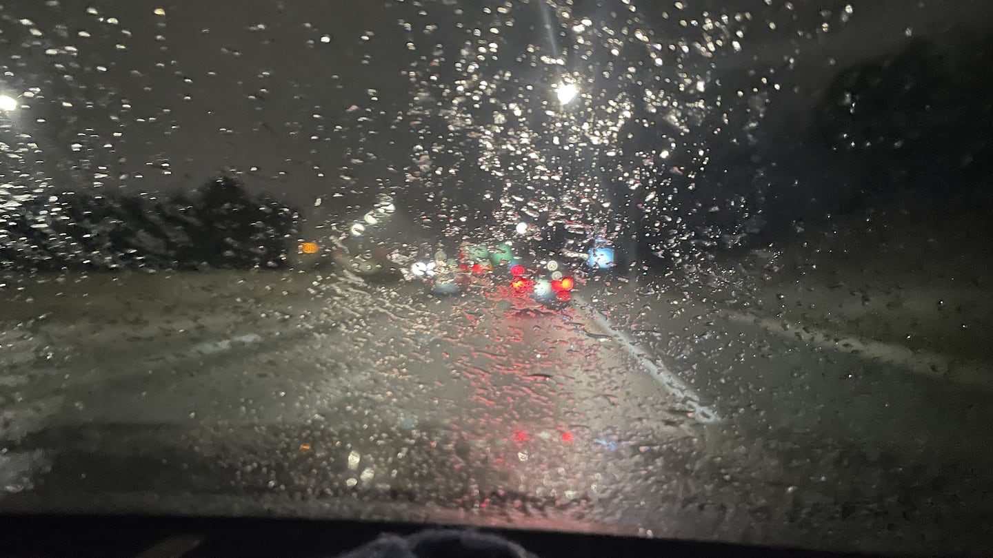
9 p.m. - Sleet is already falling north of Charlotte, with drivers along Interstate 77 seeing a swirl of precipitation on the roads near Mooresville.
8:45 p.m. - Reports are coming in that freezing rain is beginning to mix in across the area. We’re also tracking the response to branches falling in east Charlotte.
Going downhill quickly in many spots. Reports of some freezing rain mixing in. Stay off the roads, friends! pic.twitter.com/06IVsNQZ2g
— John Ahrens (@JohnAhrensWSOC9) January 25, 2026
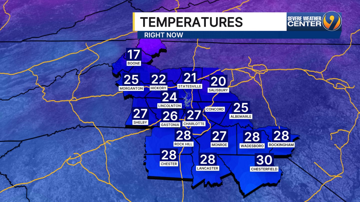
8:05 p.m. - Temperatures in the Charlotte region are below freezing, so the stage is set for precipitation to freeze on the roads.
7:30 p.m. - We’re starting to see sleet around the area - the first sign of things going downhill overnight! That sleet will change over to freezing rain overnight and fall at a light rate all through Sunday morning.
After that, it will come at us in waves - with each amount of rain freezing as it makes contact with the ground. This will produce major travel issues through Sunday.
Ice accumulations will build up over time - adding up to about 0.5″ in the Charlotte area. Some slightly higher amounts will be possible to the North. That ice will begin to weigh down on trees and lines Sunday night and increase the threat of power outages into Monday morning.
Going to adjust ice totals down just a bit. But please keep in mind, all it takes is 0.25" to create big problems. 0.25" increases tree branch weight by 3x pic.twitter.com/Gv4Ucy1XnR
— John Ahrens (@JohnAhrensWSOC9) January 24, 2026
Channel 9’s Jonathan Lowe was driving north on Interstate 85 toward Concord and saw ice starting to freeze on windshields.
Road temperatures were already below freezing by 6 p.m., as Channel 9’s Joe Puma found that one overpass had an asphalt temperature below 20 degrees.
7 p.m. - School cancellations are starting to trickle in for Monday. Gaston County Schools and Burke County Schools announced full closure for Monday.
If the power goes out, stay informed with the WSOC Mobile Apps.
Get the WSOC Weather iPhone app here.
Get the WSOC Weather Android app here.
FOLLOW OUR TEAM ON X:
- Chief Meteorologist John Ahrens
- Meteorologist Keith Monday
- Meteorologist Joe Puma
- Meteorologist Danielle Miller
(VIDEO: Flight cancellations soar as storm disrupts travel plans across North Carolina and the country)

©2026 Cox Media Group
/cloudfront-us-east-1.images.arcpublishing.com/cmg/LH3JSJEF3VBLRJLJQESEAG34AM.png)


